Australia / New South Wales
Clontarf Beach
Clontarf Beach is a 272 m-long beach in Clontarf (New South Wales, Australia). The sea averages 23.3 °C in February, its warmest month, and 18.1 °C in August; it is 21 °C or warmer in December–May.
Average sea surface temperature by month. Current month outlined.

Month by month
November at Clontarf Beach
Beach-day index 5.7/10 · Australia median 5.7
| Measure | Jan | Feb | Mar | Apr | May | Jun | Jul | Aug | Sep | Oct | Nov | Dec |
|---|---|---|---|---|---|---|---|---|---|---|---|---|
| Sea °C | 22.8 °C | 23.3 °C | 23.2 °C | 22.3 °C | 21.0 °C | 19.6 °C | 18.6 °C | 18.1 °C | 18.3 °C | 19.2 °C | 20.1 °C | 21.4 °C |
| High °C | 24° | 24° | 23° | 22° | 20° | 18° | 17° | 18° | 19° | 20° | 21° | 22° |
| Low °C | 22° | 22° | 22° | 20° | 18° | 16° | 15° | 15° | 16° | 18° | 19° | 20° |
| Rain mm | 81 | 124 | 105 | 84 | 68 | 98 | 56 | 54 | 52 | 71 | 84 | 73 |
| Cloud % | 59 | 61 | 59 | 54 | 52 | 58 | 49 | 46 | 47 | 55 | 61 | 60 |
| Wind m/s | 6.2 | 6.0 | 5.8 | 5.5 | 6.0 | 6.5 | 6.5 | 6.4 | 6.1 | 6.0 | 6.1 | 6.1 |
| Daylight h | 14.2 | 13.3 | 12.4 | 11.3 | 10.4 | 9.9 | 10.1 | 10.8 | 11.8 | 12.9 | 13.9 | 14.4 |
| Record high/low | 32°/18° | 30°/18° | 29°/17° | 27°/14° | 25°/13° | 22°/10° | 22°/10° | 23°/11° | 26°/12° | 28°/13° | 29°/13° | 30°/16° |
| Beach index | 7.7 | 7.6 | 7.5 | 7.0 | 5.8 | 4.2 | 3.9 | 3.9 | 4.6 | 5.2 | 5.7 | 6.8 |
Long-term monthly averages: air from NASA POWER (2001–2020), sea from NOAA OISST (1991–2020); records are the extremes of 2001–2020. How the index works.
When to go
The beach-day index peaks in January–March; January scores 7.7/10 with highs of 24 °C, sea at 22.8 °C and 81 mm of rain.
In January that is 0.3 points above the median of the 1,950 beaches in Australia covered by this atlas.
At its warmest the water here is 1.1 °C warmer than the Australia median for February (22.2 °C).
Across the year the sea averages 20.7 °C, warmer than 65% of the coastal beaches in the atlas.
February is the wettest month (124 mm) and September the driest (52 mm); the yearly total is about 950 mm.
Daylight runs from 9.9 hours in June to 14.4 hours in December; in mid-January the sun rises at 05:58 and sets at 20:08 local time.
Setting
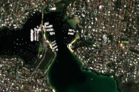
Within 1 km, the land is 47% built-up land, 45% tree cover and 7% grassland (satellite land-cover map, 2021): an urban beach. Water makes up 41% of that circle.
- Built 47%
- Tree 45%
- Grass 7%
Land cover: ESA WorldCover 2021 (10 m).
The mapped beach is tagged dog = “unleashed”.
OpenStreetMap shows no lifeguard station within 1 km. Seasonal lifeguard posts are often unmapped, so check on site.
From above
Facilities within 1 km
- 20Restaurants, cafés & bars
- 3Public toilets
- –Showers
- 6Drinking water
- 8Car parks
- –Lifeguard stations
- 1Grocery shops
- 4Water-sports spots
- 4Marinas & slipways
- 118Bus stops (1.5 km)
- 2Pharmacies & clinics
- 6Viewpoints
Food and drink mapped within 1 km: 15 restaurants and 5 cafés.
Counted within 1 km of the beach (bus stops 1.5 km) from OpenStreetMap features and Overture Maps places, release of 2026-10. Unmapped does not mean absent.
Around the beach
Viewpoints
- Parriwi Lookout 500 m SW
Nature
- Georges Head Lookout nature reserve 770 m NW
Islands in view
- Rocky Point Island 1.8 km S
Lighthouses & piers
- Pier B pier 260 m W
- Pier A pier 260 m W
- Pier C pier 270 m W
- Pier D pier 280 m W
- Pier E pier 380 m NW
- Parriwi Head Light lighthouse 760 m SW
Marinas
- Clontarf Marina 280 m NE
- Sydney Yachting Centre 320 m W
- Fergusons Boatshed 550 m NW
- d'Albora Marinas the Spit 570 m NW
Diving & boat hire
- Flying Fish Australia 330 m W
- Catalina Yachts 380 m W
- Sydney Harbour Kayaks 540 m NW
- GoBoat Sydney (The Spit, Mosman) 590 m NW
Getting there
| Airport | Code | Distance | Direction |
|---|---|---|---|
| Sydney Kingsford Smith International Airport Sydney (Mascot) | SYD | 16.9 km | south-west |
| Newcastle Airport Williamtown | NTL | 125 km | north-east |
| Bathurst Airport Bathurst | BHS | 155 km | west |
Straight-line distances from the beach; road distance is usually 20–40% longer.
Local transport: 118 bus stops within 1.5 km and 8 mapped car parks within 1 km.
95 towns and villages of 1,000+ people lie within 10 km (about 6.3M residents); within 30 km there are 363 (about 8.7M).
Map and nearby beaches
Loading map…
Open in OpenStreetMap · Directions in Google Maps
| Beach | Distance | Warmest sea | Length | Surface |
|---|---|---|---|---|
| Clontarf Beach | – | 23.3 °C | 272 m | – |
| Washaway Beach | 900 m S | 23.3 °C | 150 m | Sand |
| Castle Rock Beach | 1.2 km SE | 23.3 °C | 80 m | Sand |
| Dirty Haul Beach | 1.8 km NE | 23.3 °C | 48 m | Sand |
| Chinamans Beach | 1.8 km NW | 23.3 °C | 268 m | Sand |
| Balmoral Beach | 1.9 km S | 23.3 °C | 1.2 km | Sand |
- Washaway Beach900 m SCompare
- Castle Rock Beach1.2 km SECompare
- Dirty Haul Beach1.8 km NECompare
- Chinamans Beach1.8 km NWCompare
- Balmoral Beach1.9 km SCompare
Data on this page
- Air temperature, rain, cloud, wind, humidity: NASA POWER climatology 2001–2020, 0.5° grid.
- Sea temperature: NOAA OISST v2.1 monthly normals 1991–2020, nearest ocean cell 13.7 km away.
- Beach outline, surface, rules and public facilities: OpenStreetMap contributors (ODbL), feature w23240543; restaurants, cafés, bars and lodging: Overture Maps places (CDLA-Permissive-2.0).
- Water body, status and length: Wikidata (CC0).
- Towns and time zone: GeoNames (CC BY 4.0). Airports: OurAirports (public domain). Sunrise and sunset: NOAA solar equations.
- Photos: Wikimedia Commons, author and licence under each image.
- Satellite view: Copernicus Sentinel-2 (ESA), scene S2B_56HLH_20240423_0_L2A.
- Settlements: GeoNames places with 1,000+ inhabitants.
- Land cover: ESA WorldCover 2021, 10 m (CC BY 4.0).
Data compiled 2026-10-13. Something wrong? Report a data error.