Australia / Queensland
Streets Beach
Streets Beach is a 94 m-long sandy beach in South Brisbane (Queensland, Australia). The sea averages 26.5 °C in February, its warmest month, and 19.7 °C in August; it is 21 °C or warmer in October–June.
Average sea surface temperature by month. Current month outlined.

Reference
The South Bank Parklands are located at South Bank within the suburb of South Brisbane in Brisbane, Queensland, Australia. The parkland, on the transformed site of Brisbane's World Expo 88, was officially opened to the public on 20 June 1992.
Wikidata item Q91411875 · classified as bathing beach.
Month by month
November at Streets Beach
Beach-day index 8.7/10 · Australia median 5.7
| Measure | Jan | Feb | Mar | Apr | May | Jun | Jul | Aug | Sep | Oct | Nov | Dec |
|---|---|---|---|---|---|---|---|---|---|---|---|---|
| Sea °C | 26.2 °C | 26.5 °C | 25.7 °C | 24.2 °C | 22.5 °C | 21.3 °C | 20.1 °C | 19.7 °C | 20.3 °C | 22.0 °C | 23.6 °C | 25.1 °C |
| High °C | 28° | 27° | 26° | 24° | 22° | 20° | 20° | 21° | 23° | 24° | 26° | 27° |
| Low °C | 23° | 23° | 22° | 20° | 17° | 15° | 14° | 14° | 16° | 18° | 20° | 22° |
| Rain mm | 150 | 174 | 151 | 98 | 84 | 94 | 44 | 53 | 44 | 86 | 90 | 137 |
| Cloud % | 58 | 55 | 57 | 45 | 40 | 46 | 36 | 32 | 35 | 45 | 50 | 57 |
| Wind m/s | 4.4 | 4.5 | 4.4 | 4.1 | 3.8 | 4.1 | 3.9 | 4.0 | 4.1 | 4.2 | 4.3 | 4.4 |
| Daylight h | 13.7 | 13.1 | 12.3 | 11.5 | 10.8 | 10.4 | 10.6 | 11.1 | 11.9 | 12.7 | 13.5 | 13.9 |
| Record high/low | 36°/20° | 36°/20° | 33°/17° | 30°/13° | 28°/11° | 25°/9° | 25°/8° | 28°/8° | 32°/11° | 32°/11° | 34°/14° | 36°/17° |
| Beach index | 8.2 | 8.0 | 8.2 | 8.5 | 7.5 | 6.1 | 6.0 | 6.3 | 7.4 | 8.3 | 8.7 | 8.3 |
Long-term monthly averages: air from NASA POWER (2001–2020), sea from NOAA OISST (1991–2020); records are the extremes of 2001–2020. How the index works.
When to go
The beach-day index peaks in March–April and October–January; November scores 8.7/10 with highs of 26 °C, sea at 23.6 °C and 90 mm of rain.
In November that is 3.0 points above the median of the 1,950 beaches in Australia covered by this atlas.
At its warmest the water here is 4.3 °C warmer than the Australia median for February (22.2 °C).
Across the year the sea averages 23.1 °C, warmer than 71% of the coastal beaches in the atlas.
February is the wettest month (174 mm) and July the driest (44 mm); the yearly total is about 1,210 mm.
Daylight runs from 10.4 hours in June to 13.9 hours in December; in mid-November the sun rises at 04:49 and sets at 18:16 local time.
Setting
Within 1 km, the land is 74% built-up land, 21% tree cover and 4% grassland (satellite land-cover map, 2021): an urban beach. Water makes up 20% of that circle.
- Built 74%
- Tree 21%
- Grass 4%
Land cover: ESA WorldCover 2021 (10 m).
OpenStreetMap shows no lifeguard station within 1 km. Seasonal lifeguard posts are often unmapped, so check on site.
Photos


From above
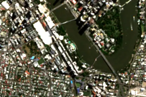
Facilities within 1 km
- 544Restaurants, cafés & bars
- 30Public toilets
- –Showers
- 91Drinking water
- 62Car parks
- –Lifeguard stations
- 64Hotels & guesthouses
- 49Grocery shops
- 1Water-sports spots
- 1Playgrounds & water parks
- 207Bus stops (1.5 km)
- 25Pharmacies & clinics
- 6Cash machines
- 7Viewpoints
- 2Historic sites
Food and drink mapped within 1 km: 323 restaurants, 139 cafés, 66 bars and 16 fast-food outlets. Accommodation: 64 hotels and guesthouses.
Counted within 1 km of the beach (bus stops 1.5 km) from OpenStreetMap features and Overture Maps places, release of 2026-10. Unmapped does not mean absent.
Around the beach
Viewpoints
- Formal Flower Garden 790 m NE
- Scout Place 980 m E
Attractions & museums
- Griffith University Art Museum museum 360 m S
- Queensland Maritime Museum museum 420 m SE
- HMAS Diamantina museum 470 m SE
- Old Government House museum 560 m E
- QUT Art Museum museum 570 m NE
- The Commissariat Store Museum museum 600 m N
Historic sites
- Confucius Statue monument 200 m SE
- Queensland Police Memorial monument 640 m NE
Nature
- Highgate Hill peak 1.1 km SW
Lighthouses & piers
- South Bank ferry 3 pier 200 m SE
- QUT Gardens Point pier 300 m E
- River Quay pier 410 m SE
- The Landing pier 430 m N
- River Outlook Pontoon pier 470 m NW
- North Quay Ferry Terminal pier 660 m N
Diving & boat hire
- CityCycle Station 19 - Goodwill Bridge/QUT 510 m E
Getting there
| Airport | Code | Distance | Direction |
|---|---|---|---|
| Brisbane International Airport Brisbane | BNE | 14.0 km | north-east |
| Gold Coast Airport Gold Coast | OOL | 90.0 km | south-east |
| Sunshine Coast Airport Maroochydore | MCY | 98.6 km | north |
Straight-line distances from the beach; road distance is usually 20–40% longer.
Local transport: 207 bus stops within 1.5 km, rail station South Bank (370 m), rail station South Brisbane (630 m), ferry terminal QUT Gardens Point (270 m), ferry terminal South Bank (320 m) and 62 mapped car parks within 1 km.
85 towns and villages of 1,000+ people lie within 10 km (about 3.3M residents); within 30 km there are 255 (about 4.9M).
Map and nearby beaches
Loading map…
Open in OpenStreetMap · Directions in Google Maps
| Beach | Distance | Warmest sea | Length | Surface |
|---|---|---|---|---|
| Streets Beach | – | 26.5 °C | 94 m | Sand |
| Pandanus Beach | 15.7 km E | 26.5 °C | 150 m | Sand |
| Nudgee Beach | 16.9 km NE | 26.5 °C | 121 m | Sand |
| Clontarf Beach | 24.9 km N | 26.5 °C | 531 m | – |
| Woody Point Beach | 25.5 km N | 26.5 °C | 118 m | – |
| Scotts Point Beach | 26.5 km N | 26.5 °C | 387 m | – |
| Margate Beach | 27.5 km N | 26.5 °C | 1.3 km | – |
- Pandanus Beach15.7 km ECompare
- Nudgee Beach16.9 km NECompare
- Clontarf Beach24.9 km NCompare
- Woody Point Beach25.5 km NCompare
- Scotts Point Beach26.5 km NCompare
- Margate Beach27.5 km NCompare
- Suttons Beach28.4 km NCompare
- Redcliffe Beach29.3 km NCompare
Data on this page
- Air temperature, rain, cloud, wind, humidity: NASA POWER climatology 2001–2020, 0.5° grid.
- Sea temperature: NOAA OISST v2.1 monthly normals 1991–2020, nearest ocean cell 15.3 km away.
- Beach outline, surface, rules and public facilities: OpenStreetMap contributors (ODbL), feature w27951887; restaurants, cafés, bars and lodging: Overture Maps places (CDLA-Permissive-2.0).
- Water body, status and length: Wikidata (CC0).
- Towns and time zone: GeoNames (CC BY 4.0). Airports: OurAirports (public domain). Sunrise and sunset: NOAA solar equations.
- Photos: Wikimedia Commons, author and licence under each image.
- Satellite view: Copernicus Sentinel-2 (ESA), scene S2C_56JMQ_20260408_0_L2A.
- Settlements: GeoNames places with 1,000+ inhabitants.
- Land cover: ESA WorldCover 2021, 10 m (CC BY 4.0).
Data compiled 2026-10-13. Something wrong? Report a data error.