Brazil / São Paulo
Ilha do Mar Casado
Ilha do Mar Casado is a 547 m-long sandy beach facing east-south-east, 8.0 km east of Guarujá (São Paulo, Brazil). The sea averages 27.1 °C in February, its warmest month, and 20.5 °C in August; it is 21 °C or warmer in September–July.
Average sea surface temperature by month. Current month outlined.

Month by month
November at Ilha do Mar Casado
Beach-day index 8.0/10 · Brazil median 7.6
| Measure | Jan | Feb | Mar | Apr | May | Jun | Jul | Aug | Sep | Oct | Nov | Dec |
|---|---|---|---|---|---|---|---|---|---|---|---|---|
| Sea °C | 26.6 °C | 27.1 °C | 26.7 °C | 25.9 °C | 23.8 °C | 22.1 °C | 21.0 °C | 20.5 °C | 21.2 °C | 22.3 °C | 23.3 °C | 25.1 °C |
| High °C | 27° | 27° | 26° | 25° | 23° | 23° | 22° | 24° | 26° | 26° | 26° | 27° |
| Low °C | 20° | 20° | 19° | 17° | 15° | 13° | 13° | 13° | 14° | 16° | 17° | 19° |
| Rain mm | 224 | 183 | 161 | 98 | 68 | 51 | 61 | 39 | 67 | 111 | 159 | 188 |
| Cloud % | 76 | 67 | 66 | 61 | 62 | 54 | 50 | 50 | 63 | 72 | 77 | 78 |
| Wind m/s | 3.0 | 2.8 | 2.9 | 2.9 | 3.0 | 2.9 | 3.1 | 3.3 | 3.5 | 3.5 | 3.5 | 3.2 |
| Daylight h | 13.5 | 12.9 | 12.3 | 11.6 | 11.0 | 10.7 | 10.8 | 11.3 | 11.9 | 12.6 | 13.3 | 13.6 |
| Record high/low | 35°/15° | 36°/15° | 34°/15° | 31°/12° | 30°/8° | 30°/6° | 31°/7° | 34°/7° | 37°/6° | 39°/11° | 36°/12° | 35°/13° |
| Beach index | 7.4 | 7.9 | 8.1 | 8.6 | 7.9 | 7.7 | 7.2 | 7.9 | 8.3 | 8.2 | 8.0 | 7.7 |
Long-term monthly averages: air from NASA POWER (2001–2020), sea from NOAA OISST (1991–2020); records are the extremes of 2001–2020. How the index works.
When to go
The beach-day index peaks in March–April and September–November; April scores 8.6/10 with highs of 25 °C, sea at 25.9 °C and 98 mm of rain.
In April that is 0.3 points above the median of the 659 beaches in Brazil covered by this atlas.
Across the year the sea averages 23.8 °C, warmer than 74% of the coastal beaches in the atlas.
January is the wettest month (224 mm) and August the driest (39 mm); the yearly total is about 1,410 mm.
Daylight runs from 10.7 hours in June to 13.6 hours in December; in mid-April the sun rises at 06:18 and sets at 17:51 local time.
Orientation, sun and shore
The shore faces east-south-east (120°). Open water fills about 42% of the horizon close by, which makes it an open stretch of shore.
At no time of year does the sun set over the sea here: sunset bearings run from 244° to 295°, behind the land.
Sunrise is over the sea in every month.
Straight out to the east-south-east there is open water for more than 2,000 km, so the beach is exposed to long ocean swell.
About 1 km offshore the sea is roughly 10 m deep and 14 m at 3 km, a shallow, gently shelving sea floor. Behind the beach the ground is about 9 m above sea level 500 m inland and 8 m at 1.5 km, a flat coastal plain.
Within 1 km, the land is 50% built-up land, 27% tree cover and 19% grassland (satellite land-cover map, 2021): an urban beach. Water makes up 52% of that circle.
- Built 50%
- Tree 27%
- Grass 19%
- Bare 3%
Land cover: ESA WorldCover 2021 (10 m). Orientation from OpenStreetMap land polygons sampled in 36 directions; depths and heights from the GEBCO 2020 grid (about 450 m cells), indicative only.
OpenStreetMap shows no lifeguard station within 1 km. Seasonal lifeguard posts are often unmapped, so check on site.
Photos


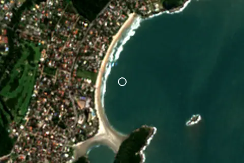
From above
Facilities within 1 km
- 14Restaurants, cafés & bars
- –Public toilets
- –Showers
- –Car parks
- –Lifeguard stations
- 34Hotels & guesthouses
- 3Grocery shops
Food and drink mapped within 1 km: 11 restaurants, 1 café, 1 bar and 1 fast-food outlet. Accommodation: 34 hotels and guesthouses.
Counted within 1 km of the beach (bus stops 1.5 km) from OpenStreetMap features and Overture Maps places, release of 2026-10. Unmapped does not mean absent.
Around the beach
Islands in view
- Ilha do Mar Casado 720 m S
- Ilha da Lage 790 m SE
- Ilha dos Arvoredos 1.7 km E
Getting there
| Airport | Code | Distance | Direction |
|---|---|---|---|
| Congonhas–Deputado Freitas Nobre Airport São Paulo | CGH | 61.0 km | north-west |
| São Paulo/Guarulhos–Governor André Franco Montoro International Airport São Paulo | GRU | 66.3 km | north-west |
| Professor Urbano Ernesto Stumpf Airport São José Dos Campos | SJK | 88.3 km | north |
Straight-line distances from the beach; road distance is usually 20–40% longer.
1 town or village of 1,000+ people lie within 10 km (about 294.9K residents); within 30 km there are 6 (about 1.6M).
Reference
Ilha do Mar Casado has an article on the PT Wikipedia: Morro do Mar Casado.
Wikidata item Q10332506 · classified as island.
When people look it up
The PT Wikipedia article was read 842 times in the 12 months to August 2026. Interest peaks in January (120 views), 4.4× the quietest month.
Map and nearby beaches
Loading map…
Open in OpenStreetMap · Directions in Google Maps
| Beach | Distance | Warmest sea | Length | Surface |
|---|---|---|---|---|
| Ilha do Mar Casado | – | 27.1 °C | 547 m | Sand |
| Pernambuco Beach | 200 m NW | 27.1 °C | 1.4 km | Sand |
| Praia do Sorocotuba | 1.8 km S | 27.1 °C | 192 m | Sand |
| Praia do Éden | 2.3 km S | 27.1 °C | 99 m | Sand |
| Perequê Beach | 3.5 km N | 27.1 °C | 2.2 km | Sand |
| Enseada Beach | 5.0 km SW | 27.1 °C | 4.9 km | Sand |
| Praia Iporanga | 7.8 km NE | 27.1 °C | 861 m | Sand |
- Pernambuco Beach200 m NWCompare
- Praia do Sorocotuba1.8 km SCompare
- Praia do Éden2.3 km SCompare
- Perequê Beach3.5 km NCompare
- Enseada Beach5.0 km SWCompare
- Praia Iporanga7.8 km NECompare
- Pitangueiras8.5 km SWCompare
- Astúrias Beach9.7 km SWCompare
Data on this page
- Air temperature, rain, cloud, wind, humidity: NASA POWER climatology 2001–2020, 0.5° grid.
- Sea temperature: NOAA OISST v2.1 monthly normals 1991–2020, nearest ocean cell 11.8 km away.
- Beach outline, surface, rules and public facilities: OpenStreetMap contributors (ODbL), feature w199419571; restaurants, cafés, bars and lodging: Overture Maps places (CDLA-Permissive-2.0).
- Water body, status and length: Wikidata (CC0).
- Towns and time zone: GeoNames (CC BY 4.0). Airports: OurAirports (public domain). Sunrise and sunset: NOAA solar equations.
- Photos: Wikimedia Commons, author and licence under each image.
- Satellite view: Copernicus Sentinel-2 (ESA), scene S2B_23KLP_20260719_1_L2A.
- Orientation: OpenStreetMap land polygons (ODbL). Depth and terrain: GEBCO 2020 grid.
- Settlements: GeoNames places with 1,000+ inhabitants.
- Land cover: ESA WorldCover 2021, 10 m (CC BY 4.0).
Data compiled 2026-10-13. Something wrong? Report a data error.