Canada / Quebec
Plage à Demers
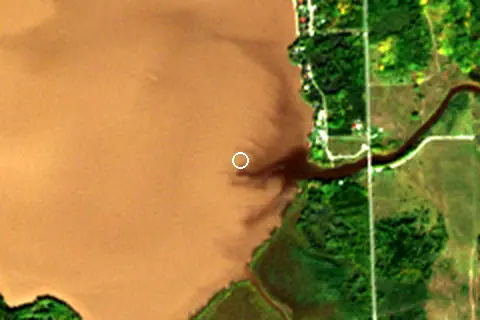
Plage à Demers is an inland beach facing west-north-west, 8.6 km north-east of Macamic (Quebec, Canada). Average daytime highs peak at 23 °C in July and drop to -12 °C in January.
Weather month by month
November at Plage à Demers
Beach-day index 3.5/10 · Canada median 2.2
| Measure | Jan | Feb | Mar | Apr | May | Jun | Jul | Aug | Sep | Oct | Nov | Dec |
|---|---|---|---|---|---|---|---|---|---|---|---|---|
| High °C | -12° | -11° | -5° | 4° | 14° | 20° | 23° | 22° | 17° | 8° | -0° | -9° |
| Low °C | -22° | -21° | -15° | -6° | 3° | 9° | 12° | 11° | 7° | 0° | -7° | -16° |
| Rain mm | 49 | 46 | 51 | 70 | 78 | 90 | 100 | 89 | 93 | 86 | 72 | 59 |
| Cloud % | 72 | 70 | 63 | 66 | 67 | 64 | 63 | 64 | 64 | 75 | 82 | 78 |
| Wind m/s | 2.8 | 3.0 | 2.9 | 2.8 | 2.5 | 2.3 | 2.2 | 2.3 | 2.4 | 2.5 | 2.8 | 2.7 |
| Daylight h | 8.7 | 10.2 | 11.8 | 13.6 | 15.2 | 16.1 | 15.8 | 14.4 | 12.7 | 10.9 | 9.2 | 8.3 |
| Record high/low | 1°/-43° | 0°/-42° | 23°/-37° | 21°/-26° | 30°/-10° | 31°/-4° | 35°/2° | 32°/3° | 31°/-4° | 25°/-14° | 18°/-24° | 6°/-44° |
| Beach index | 3.8 | 3.9 | 3.9 | 3.7 | 3.6 | 5.4 | 6.7 | 6.2 | 3.6 | 3.4 | 3.5 | 3.6 |
Long-term monthly averages: air from NASA POWER (2001–2020), sea from NOAA OISST (1991–2020); records are the extremes of 2001–2020. How the index works.
Orientation, sun and shore
The shore faces west-north-west (290°). Open lake water fills about 31% of the horizon close by, which makes it an open stretch of shore.
The beach lies on Macamic, which covers about 47 km².
The sun sets over the lake in January–November; in mid-June it goes down at 21:19 local time on a bearing of 308°.
Straight across the lake to the west-north-west, open water reaches about 5.0 km before the far shore.
Within 1 km, the land is 63% tree cover and 37% grassland (satellite land-cover map, 2021): a largely natural setting. Water makes up 61% of that circle.
- Tree 63%
- Grass 37%
Land cover: ESA WorldCover 2021 (10 m). Orientation and lake size from Natural Earth lake polygons sampled in 36 directions.
This is not a sea beach, so no sea-temperature normals are shown.
When to go
The beach-day index peaks in July–August; July scores 6.7/10 with highs of 23 °C and 100 mm of rain.
In July that is 1.9 points above the median of the 1,211 beaches in Canada covered by this atlas.
July is the wettest month (100 mm) and February the driest (46 mm); the yearly total is about 880 mm.
Daylight runs from 8.3 hours in December to 16.1 hours in June; in mid-July the sun rises at 05:27 and sets at 21:15 local time.
Nearest services
The nearest place to eat or drink is 7.9 km south-west (Restaurant le Bavard), the nearest grocery shop is 8.2 km south-west (SAQ), the nearest fuel station is 8.4 km south-west (Petro-Canada) and the nearest pharmacy or clinic is 7.3 km south-west (Chsld Macamic).
| Service | Nearest mapped | Distance | Direction |
|---|---|---|---|
| Food and drink | Restaurant le Bavard | 7.9 km | south-west |
| Groceries | SAQ | 8.2 km | south-west |
| Accommodation | Domaine St-Pierre & Fils | 6.6 km | south-west |
| Pharmacy or clinic | Chsld Macamic | 7.3 km | south-west |
| Fuel station | Petro-Canada | 8.4 km | south-west |
| Car park | Sentiers de la Micro-forêt éducative et récréative | 3.7 km | east |
| Public toilets | — | 3.7 km | east |
Straight-line distance to the nearest feature within 20 km, from OpenStreetMap and Overture Maps places. A category is missing when nothing is mapped within 20 km.
Getting there
| Airport | Code | Distance | Direction |
|---|---|---|---|
| Rouyn Noranda Airport Rouyn-Noranda | YUY | 67.1 km | south |
| Val-d'Or Airport Val-d'Or | YVO | 119 km | south-east |
| Timmins/Victor M. Power Timmins | YTS | 182 km | west |
Straight-line distances from the beach; road distance is usually 20–40% longer.
1 town or village of 1,000+ people lie within 10 km (about 2.7K residents); within 30 km there are 2 (about 10.5K).
Map and nearby beaches
Loading map…
Open in OpenStreetMap · Directions in Google Maps
| Beach | Distance | Warmest sea | Length | Surface |
|---|---|---|---|---|
| Plage à Demers | – | – | – | – |
| Plage Perreault | 27.2 km SW | – | – | – |
| Plage Rotary | 27.9 km SW | – | 149 m | – |
| Plage du Septième Rang | 28.7 km SW | – | – | – |
| Plage Gendron | 33.9 km SW | – | – | – |
| Plage chez Doucet | 35.3 km SW | – | – | – |
| Plage Cayouette | 40.0 km W | – | – | – |
- Plage Perreault27.2 km SWCompare
- Plage Rotary27.9 km SWCompare
- Plage du Septième Rang28.7 km SWCompare
- Plage Gendron33.9 km SWCompare
- Plage chez Doucet35.3 km SWCompare
- Plage Cayouette40.0 km WCompare
- Plage Peticlerc41.0 km WCompare
- Plage Trudel41.7 km WCompare
Data on this page
- Air temperature, rain, cloud, wind, humidity: NASA POWER climatology 2001–2020, 0.5° grid.
- Water body, status and length: Wikidata (CC0).
- Towns and time zone: GeoNames (CC BY 4.0). Airports: OurAirports (public domain). Sunrise and sunset: NOAA solar equations.
- Satellite view: Copernicus Sentinel-2 (ESA), scene S2B_17UPQ_20260927_0_L2A.
- Orientation: OpenStreetMap land polygons (ODbL). Depth and terrain: GEBCO 2020 grid.
- Settlements: GeoNames places with 1,000+ inhabitants.
- Nearest services: OpenStreetMap and Overture Maps places within 20 km.
- Land cover: ESA WorldCover 2021, 10 m (CC BY 4.0).
Data compiled 2026-10-13. Something wrong? Report a data error.