Chile / Atacama
Playa La Zapatilla
Playa La Zapatilla is a beach facing south-west, 18.8 km north of Caldera (Atacama, Chile). The sea averages 19.8 °C in February, its warmest month, and 14.4 °C in August; it never reaches 21 °C on average.
Average sea surface temperature by month. Current month outlined.
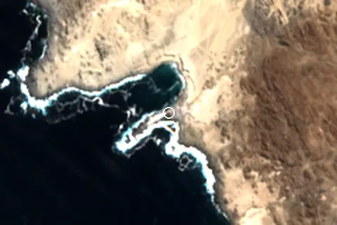
Orientation, sun and shore
The shore faces south-west (225°). Open water fills about 28% of the horizon close by, which makes it an open stretch of shore.
The sun sets over the sea in September–March; in mid-December it goes down at 20:32 local time on a bearing of 243°.
Straight out to the south-west there is open water for more than 2,000 km, so the beach is exposed to long ocean swell.
About 1 km offshore the sea is roughly 65 m deep and 74 m at 3 km, so deep water starts close to shore. Behind the beach the ground is about 28 m above sea level 500 m inland and 89 m at 1.5 km.
Within 1 km, the land is 99% bare ground, sand or rock (satellite land-cover map, 2021): open dunes, sand or rock. Water makes up 40% of that circle.
- Bare 99%
Land cover: ESA WorldCover 2021 (10 m). Orientation from OpenStreetMap land polygons sampled in 36 directions; depths and heights from the GEBCO 2020 grid (about 450 m cells), indicative only.
Nearest services
The nearest place to eat or drink is 18.2 km south (Puerto Bahia), the nearest grocery shop is 18.6 km south (Mercadito Express Caldera), the nearest fuel station is 18.7 km south (COPEC) and the nearest pharmacy or clinic is 19.1 km south (Veterinaria municipal, Caldera).
| Service | Nearest mapped | Distance | Direction |
|---|---|---|---|
| Food and drink | Puerto Bahia | 18.2 km | south |
| Groceries | Mercadito Express Caldera | 18.6 km | south |
| Accommodation | Hospedaje Boutique Ckamur | 17.7 km | south |
| Pharmacy or clinic | Veterinaria municipal, Caldera | 19.1 km | south |
| Fuel station | COPEC | 18.7 km | south |
| Car park | — | 2.8 km | north |
| Public toilets | — | 18.7 km | south |
| Bus stop | — | 10.8 km | south |
Straight-line distance to the nearest feature within 20 km, from OpenStreetMap and Overture Maps places. A category is missing when nothing is mapped within 20 km.
Getting there
| Airport | Code | Distance | Direction |
|---|---|---|---|
| Desierto de Atacama Airport Copiapo | CPO | 40.4 km | south |
| Ricardo García Posada Airport El Salvador | ESR | 123 km | north-east |
| La Florida Airport La Serena-Coquimbo | LSC | 338 km | south |
Straight-line distances from the beach; road distance is usually 20–40% longer.
No town of 1,000+ people lies within 10 km; within 30 km there are 1 (about 16.2K).
Map and nearby beaches
Loading map…
Open in OpenStreetMap · Directions in Google Maps
| Beach | Distance | Warmest sea | Length | Surface |
|---|---|---|---|---|
| Playa La Zapatilla | – | 19.8 °C | – | – |
| Playa Brava | 18.3 km S | 19.5 °C | 528 m | Sand |
| Playa La Virgen | 53.5 km S | 19.2 °C | 135 m | Sand |
- Playa Brava18.3 km SCompare
- Playa La Virgen53.5 km SCompare
Data on this page
- Sea temperature: NOAA OISST v2.1 monthly normals 1991–2020, nearest ocean cell 6.6 km away.
- Beach outline, surface, rules and public facilities: OpenStreetMap contributors (ODbL), feature n8666309838; restaurants, cafés, bars and lodging: Overture Maps places (CDLA-Permissive-2.0).
- Towns and time zone: GeoNames (CC BY 4.0). Airports: OurAirports (public domain). Sunrise and sunset: NOAA solar equations.
- Satellite view: Copernicus Sentinel-2 (ESA), scene S2B_19JCL_20260420_0_L2A.
- Orientation: OpenStreetMap land polygons (ODbL). Depth and terrain: GEBCO 2020 grid.
- Settlements: GeoNames places with 1,000+ inhabitants.
- Nearest services: OpenStreetMap and Overture Maps places within 20 km.
- Land cover: ESA WorldCover 2021, 10 m (CC BY 4.0).
- Search popularity: about 1.3K Google searches a month for the name (KeywordTool, October 2026).
Data compiled 2026-10-13. Something wrong? Report a data error.