Croatia / Zadar
Plaža Sakarun
Plaža Sakarun is a 300 m-long pebble beach facing east-south-east on the Adriatic Sea, 18.4 km west of Ugljan (Zadar, Croatia). The sea averages 25.0 °C in August, its warmest month, and 12.5 °C in February; it is 21 °C or warmer in June–September.
Average sea surface temperature by month. Current month outlined.

Month by month
October at Plaža Sakarun
Beach-day index 4.5/10 · Croatia median 4.4
| Measure | Jan | Feb | Mar | Apr | May | Jun | Jul | Aug | Sep | Oct | Nov | Dec |
|---|---|---|---|---|---|---|---|---|---|---|---|---|
| Sea °C | 13.6 °C | 12.5 °C | 12.6 °C | 14.2 °C | 17.7 °C | 21.7 °C | 24.3 °C | 25.0 °C | 22.8 °C | 20.2 °C | 17.7 °C | 15.4 °C |
| High °C | 7° | 8° | 11° | 16° | 20° | 25° | 28° | 28° | 23° | 18° | 13° | 9° |
| Low °C | 2° | 2° | 5° | 9° | 13° | 17° | 20° | 19° | 15° | 11° | 8° | 4° |
| Rain mm | 100 | 99 | 83 | 74 | 85 | 59 | 48 | 62 | 122 | 119 | 144 | 118 |
| Cloud % | 64 | 60 | 56 | 54 | 52 | 43 | 32 | 32 | 44 | 53 | 64 | 61 |
| Wind m/s | 4.2 | 4.5 | 4.1 | 3.2 | 2.9 | 2.6 | 2.6 | 2.6 | 3.2 | 3.4 | 3.9 | 4.2 |
| Daylight h | 9.2 | 10.4 | 11.8 | 13.4 | 14.7 | 15.5 | 15.2 | 14.1 | 12.6 | 11.1 | 9.7 | 8.9 |
| Record high/low | 14°/-9° | 16°/-9° | 20°/-8° | 24°/-1° | 32°/5° | 34°/8° | 36°/13° | 37°/11° | 32°/8° | 27°/2° | 23°/-0° | 16°/-7° |
| Beach index | 2.5 | 2.5 | 2.8 | 2.9 | 5.0 | 8.7 | 9.3 | 9.2 | 7.5 | 4.5 | 3.1 | 2.5 |
Long-term monthly averages: air from NASA POWER (2001–2020), sea from NOAA OISST (1991–2020); records are the extremes of 2001–2020. How the index works.
When to go
The beach-day index peaks in July–August; July scores 9.3/10 with highs of 28 °C, sea at 24.3 °C and 48 mm of rain.
That matches the median for beaches in Croatia in the same month.
At its warmest the water here is 0.5 °C warmer than the Croatia median for August (24.5 °C).
Across the year the sea averages 18.1 °C, cooler than 57% of the coastal beaches in the atlas.
November is the wettest month (144 mm) and July the driest (48 mm); the yearly total is about 1,110 mm.
Daylight runs from 8.9 hours in December to 15.5 hours in June; in mid-July the sun rises at 05:30 and sets at 20:42 local time.
Orientation, sun and shore
The shore faces east-south-east (118°). Open water fills about 25% of the horizon close by, which makes it an open stretch of shore.
At no time of year does the sun set over the sea here: sunset bearings run from 238° to 304°, behind the land.
Sunrise is over the sea in November–January.
The opposite shore is only about 1.0 km away to the east-south-east, which keeps the water sheltered from big waves. The beach is on Dugi otok, an island of about 111 km².
Within 1 km, the land is 90% tree cover, 3% shrubland and 3% grassland (satellite land-cover map, 2021): a largely natural setting. Water makes up 33% of that circle.
- Tree 90%
- Shrub 3%
- Grass 3%
- Bare 3%
Land cover: ESA WorldCover 2021 (10 m). Orientation from OpenStreetMap land polygons sampled in 36 directions; depths and heights from the GEBCO 2020 grid (about 450 m cells), indicative only.
Bathing water quality
The official EU bathing-water site “Uvala Saharun”, 60 m from the beach centre, was rated Excellent for the 2025 season. It was Excellent in 11 of its 11 classified seasons since 2015.
- 2015Excellent
- 2016Excellent
- 2017Excellent
- 2018Excellent
- 2019Excellent
- 2020Excellent
- 2021Excellent
- 2022Excellent
- 2023Excellent
- 2024Excellent
- 2025Excellent
Source: European Environment Agency, EU Bathing Water Directive assessments · national site profile. Classes are based on four seasons of bacteriological sampling.
OpenStreetMap shows no lifeguard station within 1 km. Seasonal lifeguard posts are often unmapped, so check on site.
Photos


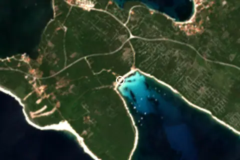
From above
Facilities within 1 km
- 2Restaurants, cafés & bars
- 1Public toilets
- –Showers
- 1Car parks
- –Lifeguard stations
- 1Hotels & guesthouses
- 1Campsites
- 3Bus stops (1.5 km)
Food and drink mapped within 1 km: 1 restaurant and 1 bar. Accommodation: 1 hotel or guesthouse.
Counted within 1 km of the beach (bus stops 1.5 km) from OpenStreetMap features and Overture Maps places, release of 2026-10. Unmapped does not mean absent.
Around the beach
Nature
- Vela lopata peak 470 m S
- Straža peak 620 m NE
- Pećina peak 1.4 km E
Campsites
- Camp Mandarino 840 m NW
Getting there
| Airport | Code | Distance | Direction |
|---|---|---|---|
| Zadar Airport Zadar | ZAD | 38.7 km | east |
| Pula Airport Pula | PUY | 113 km | north-west |
| Rijeka Airport Rijeka(Omišalj) | RJK | 123 km | north |
Straight-line distances from the beach; road distance is usually 20–40% longer.
Local transport: 3 bus stops within 1.5 km and 1 mapped car park within 1 km.
No town of 1,000+ people lies within 10 km; within 30 km there are 7 (about 77.4K).
Reference
Plaža Sakarun has an article on the HR Wikipedia: Sakarun.
Wikidata item Q6961232.
When people look it up
The HR Wikipedia article was read 1,260 times in the 12 months to August 2026. Interest peaks in July (329 views), 23.5× the quietest month.
Map and nearby beaches
Loading map…
Open in OpenStreetMap · Directions in Google Maps
| Beach | Distance | Warmest sea | Length | Surface |
|---|---|---|---|---|
| Plaža Sakarun | – | 25.0 °C | 300 m | Pebble |
| Plaža Žitna | 26.6 km NE | 24.5 °C | 190 m | – |
| Plaža Uskok | 27.2 km E | 25.0 °C | 321 m | – |
- Plaža Žitna26.6 km NECompare
- Plaža Uskok27.2 km ECompare
Data on this page
- Air temperature, rain, cloud, wind, humidity: NASA POWER climatology 2001–2020, 0.5° grid.
- Sea temperature: NOAA OISST v2.1 monthly normals 1991–2020, nearest ocean cell 1.0 km away.
- Beach outline, surface, rules and public facilities: OpenStreetMap contributors (ODbL), feature w229112140; restaurants, cafés, bars and lodging: Overture Maps places (CDLA-Permissive-2.0).
- Water body, status and length: Wikidata (CC0).
- Towns and time zone: GeoNames (CC BY 4.0). Airports: OurAirports (public domain). Sunrise and sunset: NOAA solar equations.
- Photos: Wikimedia Commons, author and licence under each image.
- Satellite view: Copernicus Sentinel-2 (ESA), scene S2A_33TVJ_20230626_0_L2A.
- Orientation: OpenStreetMap land polygons (ODbL). Depth and terrain: GEBCO 2020 grid.
- Bathing-water quality: European Environment Agency (site HRBWC-COAST-HR4-4150).
- Settlements: GeoNames places with 1,000+ inhabitants.
- Land cover: ESA WorldCover 2021, 10 m (CC BY 4.0).
- Search popularity: about 720 Google searches a month for the name (KeywordTool, October 2026).
Data compiled 2026-10-13. Something wrong? Report a data error.