France / Auvergne-Rhône-Alpes
Excenevex
Excenevex is a 463 m-long sandy inland beach, 2.6 km north-west of Sciez (Auvergne-Rhône-Alpes, France). Average daytime highs peak at 22 °C in July and drop to 1 °C in January.
Weather month by month
November at Excenevex
Beach-day index 3.4/10 · France median 2.8
| Measure | Jan | Feb | Mar | Apr | May | Jun | Jul | Aug | Sep | Oct | Nov | Dec |
|---|---|---|---|---|---|---|---|---|---|---|---|---|
| High °C | 1° | 2° | 7° | 12° | 15° | 20° | 22° | 21° | 17° | 13° | 7° | 2° |
| Low °C | -6° | -6° | -2° | 2° | 6° | 11° | 12° | 12° | 8° | 4° | -1° | -5° |
| Rain mm | 92 | 71 | 90 | 81 | 126 | 114 | 115 | 120 | 81 | 94 | 90 | 101 |
| Cloud % | 76 | 74 | 70 | 69 | 73 | 66 | 59 | 60 | 60 | 68 | 75 | 76 |
| Wind m/s | 2.7 | 2.7 | 2.8 | 2.5 | 2.5 | 2.5 | 2.4 | 2.3 | 2.3 | 2.4 | 2.4 | 2.6 |
| Daylight h | 9.0 | 10.3 | 11.8 | 13.5 | 15.0 | 15.8 | 15.5 | 14.2 | 12.6 | 11.0 | 9.5 | 8.6 |
| Record high/low | 10°/-22° | 16°/-26° | 19°/-21° | 22°/-8° | 28°/-3° | 33°/-0° | 32°/4° | 33°/4° | 28°/-1° | 25°/-7° | 19°/-15° | 12°/-19° |
| Beach index | 3.3 | 3.6 | 3.4 | 3.5 | 3.0 | 4.8 | 6.1 | 5.8 | 3.8 | 3.4 | 3.4 | 3.2 |
Long-term monthly averages: air from NASA POWER (2001–2020), sea from NOAA OISST (1991–2020); records are the extremes of 2001–2020. How the index works.
Orientation, sun and shore
Within 1 km, the land is 50% tree cover, 20% cropland and 16% grassland (satellite land-cover map, 2021): a mixed, lightly developed setting. Water makes up 44% of that circle.
- Tree 50%
- Crop 20%
- Grass 16%
- Built 13%
Land cover: ESA WorldCover 2021 (10 m). Orientation and lake size from Natural Earth lake polygons sampled in 36 directions.
The mapped beach is tagged as not allowing dogs.
The beach is tagged as supervised.
This is not a sea beach, so no sea-temperature normals are shown.
Bathing water quality
The official EU bathing-water site “Excenevex Municipale”, 70 m from the beach centre, was rated Good for the 2025 season. It was Excellent in 4 of its 11 classified seasons since 2015.
- 2015Good
- 2016Good
- 2017Excellent
- 2018Excellent
- 2019Excellent
- 2020Excellent
- 2021Sufficient
- 2022Good
- 2023Good
- 2024Good
- 2025Good
Source: European Environment Agency, EU Bathing Water Directive assessments · national site profile. Classes are based on four seasons of bacteriological sampling.
When to go
The beach-day index peaks in July–August; July scores 6.1/10 with highs of 22 °C and 115 mm of rain.
In July that is 1.8 points below the median of the 625 beaches in France covered by this atlas.
May is the wettest month (126 mm) and February the driest (71 mm); the yearly total is about 1,180 mm.
Daylight runs from 8.6 hours in December to 15.8 hours in June; in mid-July the sun rises at 05:56 and sets at 21:24 local time.
Facilities within 1 km
- 10Restaurants, cafés & bars
- 9Public toilets
- –Showers
- 2Drinking water
- 21Car parks
- –Lifeguard stations
- 4Hotels & guesthouses
- 4Campsites
- 1Water-sports spots
- 8Bus stops (1.5 km)
- 2Viewpoints
Food and drink mapped within 1 km: 7 restaurants and 3 bars. Accommodation: 4 hotels and guesthouses.
Counted within 1 km of the beach (bus stops 1.5 km) from OpenStreetMap features and Overture Maps places, release of 2026-10. Unmapped does not mean absent.
Around the beach
Attractions & museums
- Ailes Anciennes de Haute-Savoie museum 690 m S
Diving & boat hire
- Relax Leman Location 360 m SW
Campsites
- Camping la Pourvoirie des Ellandes 500 m SW
- Campeole la Pinede - Meer van Geneve 860 m SE
- Camping la Pinède 940 m SW
Getting there
| Airport | Code | Distance | Direction |
|---|---|---|---|
| Geneva International Airport Geneva | GVA | 22.9 km | south-west |
| Annecy Meythet airport Annecy | NCY | 50.9 km | south-west |
| Chambéry Aix les Bains airport Chambéry | CMF | 87.4 km | south-west |
Straight-line distances from the beach; road distance is usually 20–40% longer.
Local transport: 8 bus stops within 1.5 km, ferry terminal Excenevex (800 m) and 21 mapped car parks within 1 km.
14 towns and villages of 1,000+ people lie within 10 km (about 63.6K residents); within 30 km there are 132 (about 981.3K).
Map and nearby beaches
Loading map…
Open in OpenStreetMap · Directions in Google Maps
| Beach | Distance | Warmest sea | Length | Surface |
|---|---|---|---|---|
| Excenevex | – | – | 463 m | Sand |
| Genève-Plage | 20.9 km SW | – | 195 m | – |
| plage des Eaux-Vives | 21.5 km SW | – | 78 m | Gravel |
| Albigny beach | 52.1 km S | – | 165 m | – |
| Impérial beach | 52.4 km S | – | 89 m | Grass |
- Genève-Plage20.9 km SWCompare
- plage des Eaux-Vives21.5 km SWCompare
- Albigny beach52.1 km SCompare
- Impérial beach52.4 km SCompare
Data on this page
- Air temperature, rain, cloud, wind, humidity: NASA POWER climatology 2001–2020, 0.5° grid.
- Beach outline, surface, rules and public facilities: OpenStreetMap contributors (ODbL), feature r6373637; restaurants, cafés, bars and lodging: Overture Maps places (CDLA-Permissive-2.0).
- Towns and time zone: GeoNames (CC BY 4.0). Airports: OurAirports (public domain). Sunrise and sunset: NOAA solar equations.
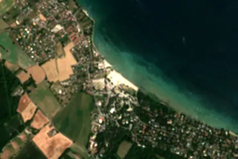
- Satellite view: Copernicus Sentinel-2 (ESA), scene S2A_31TGM_20250811_1_L2A.
- Orientation: OpenStreetMap land polygons (ODbL). Depth and terrain: GEBCO 2020 grid.
- Bathing-water quality: European Environment Agency (site FRK2874121D074030).
- Settlements: GeoNames places with 1,000+ inhabitants.
- Land cover: ESA WorldCover 2021, 10 m (CC BY 4.0).
- Search popularity: about 2.9K Google searches a month for the name (KeywordTool, October 2026).
Data compiled 2026-10-13. Something wrong? Report a data error.