France / Brittany
plage de l'île Saint-Nicolas
plage de l'île Saint-Nicolas is a 488 m-long sandy beach on the North Atlantic Ocean, 17.2 km south-east of Loctudy (Brittany, France). The sea averages 18.1 °C in August, its warmest month, and 10.3 °C in March; it never reaches 21 °C on average.
Average sea surface temperature by month. Current month outlined.
Month by month
November at plage de l'île Saint-Nicolas
Beach-day index 2.1/10 · France median 2.8
| Measure | Jan | Feb | Mar | Apr | May | Jun | Jul | Aug | Sep | Oct | Nov | Dec |
|---|---|---|---|---|---|---|---|---|---|---|---|---|
| Sea °C | 11.2 °C | 10.5 °C | 10.3 °C | 11.6 °C | 13.7 °C | 16.0 °C | 17.5 °C | 18.1 °C | 17.2 °C | 15.9 °C | 14.1 °C | 12.4 °C |
| High °C | 9° | 9° | 11° | 14° | 17° | 21° | 23° | 23° | 21° | 17° | 12° | 9° |
| Low °C | 4° | 3° | 4° | 6° | 8° | 11° | 13° | 13° | 11° | 9° | 6° | 4° |
| Rain mm | 103 | 85 | 68 | 56 | 55 | 52 | 54 | 55 | 44 | 96 | 107 | 109 |
| Cloud % | 87 | 83 | 78 | 69 | 69 | 66 | 66 | 67 | 65 | 76 | 83 | 87 |
| Wind m/s | 5.7 | 5.7 | 5.5 | 4.9 | 4.7 | 4.5 | 4.5 | 4.5 | 4.5 | 5.0 | 5.4 | 5.6 |
| Daylight h | 8.8 | 10.2 | 11.8 | 13.6 | 15.1 | 16.0 | 15.7 | 14.4 | 12.7 | 11.0 | 9.3 | 8.5 |
| Record high/low | 14°/-9° | 16°/-7° | 21°/-5° | 25°/-2° | 27°/1° | 32°/5° | 33°/8° | 38°/8° | 32°/5° | 27°/1° | 19°/-4° | 15°/-5° |
| Beach index | 2.0 | 2.2 | 2.4 | 2.7 | 2.9 | 4.8 | 6.2 | 6.4 | 5.3 | 2.6 | 2.1 | 2.0 |
Long-term monthly averages: air from NASA POWER (2001–2020), sea from NOAA OISST (1991–2020); records are the extremes of 2001–2020. How the index works.
When to go
The beach-day index peaks in July–August; August scores 6.4/10 with highs of 23 °C, sea at 18.1 °C and 55 mm of rain.
In August that is 1.6 points below the median of the 625 beaches in France covered by this atlas.
At its warmest the water here is 4.0 °C cooler than the France median for August (22.1 °C).
Across the year the sea averages 14.0 °C, cooler than 77% of the coastal beaches in the atlas.
December is the wettest month (109 mm) and September the driest (44 mm); the yearly total is about 880 mm.
Daylight runs from 8.5 hours in December to 16.0 hours in June; in mid-August the sun rises at 07:10 and sets at 21:31 local time.
Orientation, sun and shore
Water surrounds this spot on about 100% of the horizon within 1.5 km: it sits on a spit, headland or islet rather than a straight shore.
The sun sets over the sea in every month; in mid-June it goes down at 22:15 local time on a bearing of 307°.
Sunrise is over the sea in every month.
Within 1 km, the land is 71% grassland, 19% wetland and 7% bare ground, sand or rock (satellite land-cover map, 2021): a largely natural setting. Water makes up 89% of that circle.
- Grass 71%
- Wetland 19%
- Bare 7%
Land cover: ESA WorldCover 2021 (10 m). Orientation from OpenStreetMap land polygons sampled in 36 directions; depths and heights from the GEBCO 2020 grid (about 450 m cells), indicative only.
Bathing water quality
The official EU bathing-water site “Glenan-St Nicolas”, 130 m from the beach centre, was rated Excellent for the 2025 season. It was Excellent in 11 of its 11 classified seasons since 2015.
- 2015Excellent
- 2016Excellent
- 2017Excellent
- 2018Excellent
- 2019Excellent
- 2020Excellent
- 2021Excellent
- 2022Excellent
- 2023Excellent
- 2024Excellent
- 2025Excellent
Source: European Environment Agency, EU Bathing Water Directive assessments · national site profile. Classes are based on four seasons of bacteriological sampling.
The sea peaks at 18.1 °C in August. Most swimmers find water below 20 °C cold; a wetsuit is common here.
Facilities within 1 km
- 2Restaurants, cafés & bars
- 2Public toilets
- –Showers
- –Car parks
- –Lifeguard stations
Food and drink mapped within 1 km: 1 restaurant and 1 fast-food outlet.
Counted within 1 km of the beach (bus stops 1.5 km) from OpenStreetMap features and Overture Maps places, release of 2026-10. Unmapped does not mean absent.
Around the beach
Nature
- Réserve naturelle nationale de Saint-Nicolas des Glénan nature reserve 210 m SE
Islands in view
- Île Saint-Nicolas 170 m SW
- Île de Brunec 460 m N
- Île de Bananec 700 m E
- Roc'h ar C'hoar 760 m W
- Le Veau 890 m S
- Le Huic 1.1 km NW
Getting there
| Airport | Code | Distance | Direction |
|---|---|---|---|
| Brest Bretagne airport Brest | BES | 86.1 km | north |
| Rennes-Saint-Jacques Airport Saint-Jacques-de-la-Lande, Ille-et-Vilaine | RNS | 173 km | east |
| Nantes Atlantique Airport Nantes | NTE | 191 km | east |
Straight-line distances from the beach; road distance is usually 20–40% longer.
No town of 1,000+ people lies within 10 km; within 30 km there are 26 (about 120.1K).
Map and nearby beaches
Loading map…
Open in OpenStreetMap · Directions in Google Maps
| Beach | Distance | Warmest sea | Length | Surface |
|---|---|---|---|---|
| plage de l'île Saint-Nicolas | – | 18.1 °C | 488 m | Sand |
| plages de Trévignon | 15.4 km NE | 17.9 °C | 1.6 km | Sand |
| Raguenes | 17.2 km NE | 17.9 °C | – | – |
| Plage de Tahiti | 17.3 km NE | 17.9 °C | 910 m | Sand |
| plage de Porzh Karn | 28.6 km NW | 17.6 °C | 1.7 km | – |
| plage de la Torche | 28.8 km NW | 17.6 °C | 1.4 km | Sand |
| plage de Tronoën | 29.4 km NW | 17.6 °C | 1.7 km | Sand |
- plages de Trévignon15.4 km NECompare
- Raguenes17.2 km NECompare
- Plage de Tahiti17.3 km NECompare
- plage de Porzh Karn28.6 km NWCompare
- plage de la Torche28.8 km NWCompare
- plage de Tronoën29.4 km NWCompare
- plage de Kermabec32.0 km NWCompare
- plage du Kérou33.2 km ECompare
Data on this page
- Air temperature, rain, cloud, wind, humidity: NASA POWER climatology 2001–2020, 0.5° grid.
- Sea temperature: NOAA OISST v2.1 monthly normals 1991–2020, nearest ocean cell 14.5 km away.
- Beach outline, surface, rules and public facilities: OpenStreetMap contributors (ODbL), feature r2835297; restaurants, cafés, bars and lodging: Overture Maps places (CDLA-Permissive-2.0).
- Water body, status and length: Wikidata (CC0).
- Towns and time zone: GeoNames (CC BY 4.0). Airports: OurAirports (public domain). Sunrise and sunset: NOAA solar equations.
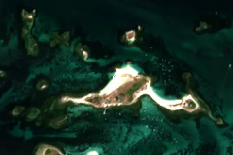
- Satellite view: Copernicus Sentinel-2 (ESA), scene S2A_30TVT_20260706_0_L2A.
- Orientation: OpenStreetMap land polygons (ODbL). Depth and terrain: GEBCO 2020 grid.
- Bathing-water quality: European Environment Agency (site FRH0229058M029852).
- Settlements: GeoNames places with 1,000+ inhabitants.
- Land cover: ESA WorldCover 2021, 10 m (CC BY 4.0).
Data compiled 2026-10-13. Something wrong? Report a data error.