Poland / Mazovia
Poniatówka Beach
Poniatówka Beach is a 258 m-long sandy inland beach, 1.9 km north-east of Śródmieście (Mazovia, Poland). Average daytime highs peak at 25 °C in July and drop to -1 °C in January.

Weather month by month
November at Poniatówka Beach
Beach-day index 3.6/10 · Poland median 2.3
| Measure | Jan | Feb | Mar | Apr | May | Jun | Jul | Aug | Sep | Oct | Nov | Dec |
|---|---|---|---|---|---|---|---|---|---|---|---|---|
| High °C | -1° | 1° | 7° | 14° | 20° | 23° | 25° | 25° | 20° | 13° | 6° | 1° |
| Low °C | -7° | -6° | -2° | 3° | 9° | 13° | 15° | 14° | 9° | 4° | 1° | -4° |
| Rain mm | 44 | 37 | 37 | 40 | 72 | 67 | 74 | 64 | 51 | 49 | 44 | 45 |
| Cloud % | 82 | 80 | 70 | 60 | 63 | 62 | 65 | 60 | 61 | 70 | 82 | 81 |
| Wind m/s | 5.1 | 4.9 | 4.9 | 4.3 | 4.1 | 3.9 | 3.8 | 3.6 | 4.0 | 4.4 | 4.7 | 4.9 |
| Daylight h | 8.2 | 9.9 | 11.8 | 13.9 | 15.7 | 16.7 | 16.3 | 14.8 | 12.8 | 10.8 | 8.8 | 7.8 |
| Record high/low | 12°/-33° | 12°/-28° | 21°/-19° | 28°/-6° | 31°/-4° | 34°/3° | 34°/8° | 36°/6° | 34°/-0° | 24°/-6° | 18°/-13° | 12°/-20° |
| Beach index | 3.5 | 3.7 | 3.8 | 4.0 | 5.3 | 7.3 | 8.4 | 8.5 | 5.5 | 3.8 | 3.6 | 3.6 |
Long-term monthly averages: air from NASA POWER (2001–2020), sea from NOAA OISST (1991–2020); records are the extremes of 2001–2020. How the index works.
Setting
Within 1 km, the land is 48% built-up land, 47% tree cover and 5% grassland (satellite land-cover map, 2021): an urban beach. Water makes up 15% of that circle.
- Built 48%
- Tree 47%
- Grass 5%
Land cover: ESA WorldCover 2021 (10 m).
This is not a sea beach, so no sea-temperature normals are shown.
When to go
The beach-day index peaks in July–August; August scores 8.5/10 with highs of 25 °C and 64 mm of rain.
In August that is 2.5 points above the median of the 121 beaches in Poland covered by this atlas.
July is the wettest month (74 mm) and February the driest (37 mm); the yearly total is about 620 mm.
Daylight runs from 7.8 hours in December to 16.7 hours in June; in mid-August the sun rises at 05:17 and sets at 20:03 local time.
Facilities within 1 km
- 158Restaurants, cafés & bars
- 18Public toilets
- –Showers
- 1Drinking water
- 132Car parks
- –Lifeguard stations
- 13Hotels & guesthouses
- 20Grocery shops
- 5Water-sports spots
- 1Playgrounds & water parks
- 94Bus stops (1.5 km)
- 9Pharmacies & clinics
- 18Cash machines
- 6Bike rental
- 4Historic sites
Food and drink mapped within 1 km: 102 restaurants, 16 cafés, 33 bars and 7 fast-food outlets. Accommodation: 13 hotels and guesthouses.
Counted within 1 km of the beach (bus stops 1.5 km) from OpenStreetMap features and Overture Maps places, release of 2026-10. Unmapped does not mean absent.
Photos


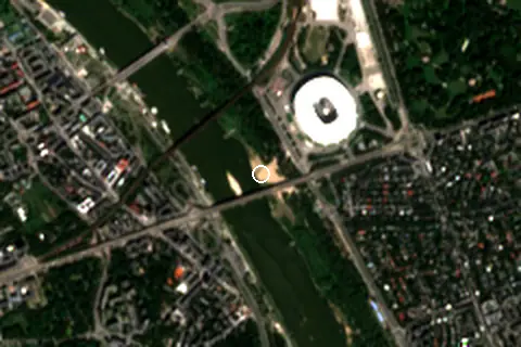
From above
Around the beach
Attractions & museums
- Wielka Fabryka Elfów Warszawa attraction 270 m NE
- Muzeum Azji i Pacyfiku museum 490 m SW
Historic sites
- Wiadukt i Most im. ks. Józefa Poniatowskiego monument 730 m SW
- Pomnik Pamięci Dowódców Obrony Elektrowni w Powstaniu Warszawskim monument 790 m NW
- Pomnik Jerzego Waszyngtona monument 800 m E
- Pomnik Chwała Saperom monument 910 m S
Diving & boat hire
- Veturilo 9681 210 m E
- Rejsowisko 300 m W
- Veturilo 9528 560 m W
- Veturilo 9682 | 96821 | 9715 670 m E
- Motolodki 870 m S
Getting there
| Airport | Code | Distance | Direction |
|---|---|---|---|
| Warsaw Chopin Airport Warsaw | WAW | 9.4 km | south-west |
| Warsaw Modlin Airport Nowy Dwór Mazowiecki | WMI | 35.6 km | north-west |
| Warsaw Radom Airport Radom | RDO | 95.0 km | south |
Straight-line distances from the beach; road distance is usually 20–40% longer.
Local transport: 94 bus stops within 1.5 km, rail station Warszawa Stadion (900 m), rail station Warszawa Powiśle (970 m), ferry terminal Stadion Narodowy (30 m), ferry terminal Most Poniatowskiego (250 m) and 132 mapped car parks within 1 km.
16 towns and villages of 1,000+ people lie within 10 km (about 3.2M residents); within 30 km there are 82 (about 4M).
Map and nearby beaches
Loading map…
Open in OpenStreetMap · Directions in Google Maps
| Beach | Distance | Warmest sea | Length | Surface |
|---|---|---|---|---|
| Poniatówka Beach | – | – | 258 m | Sand |
| Plaża Świder | 18.3 km SE | – | 97 m | – |
| Nieporęt | 22.2 km N | – | 78 m | Sand |
| Zegrze | 25.0 km N | – | – | – |
| Urle | 50.6 km NE | – | – | – |
Data on this page
- Air temperature, rain, cloud, wind, humidity: NASA POWER climatology 2001–2020, 0.5° grid.
- Beach outline, surface, rules and public facilities: OpenStreetMap contributors (ODbL), feature w346115377; restaurants, cafés, bars and lodging: Overture Maps places (CDLA-Permissive-2.0).
- Water body, status and length: Wikidata (CC0).
- Towns and time zone: GeoNames (CC BY 4.0). Airports: OurAirports (public domain). Sunrise and sunset: NOAA solar equations.
- Photos: Wikimedia Commons, author and licence under each image.
- Satellite view: Copernicus Sentinel-2 (ESA), scene S2B_34UEC_20260814_0_L2A.
- Settlements: GeoNames places with 1,000+ inhabitants.
- Land cover: ESA WorldCover 2021, 10 m (CC BY 4.0).
Data compiled 2026-10-13. Something wrong? Report a data error.