Spain / Catalonia
Cap de Sant Pere
Cap de Sant Pere is a 590 m-long sandy beach facing south-south-east on the Mediterranean Sea, 2.8 km west of Salou (Catalonia, Spain). The sea averages 25.9 °C in August, its warmest month, and 13.1 °C in February; it is 21 °C or warmer in June–October.
Average sea surface temperature by month. Current month outlined.

Month by month
November at Cap de Sant Pere
Beach-day index 4.0/10 · Spain median 3.7
| Measure | Jan | Feb | Mar | Apr | May | Jun | Jul | Aug | Sep | Oct | Nov | Dec |
|---|---|---|---|---|---|---|---|---|---|---|---|---|
| Sea °C | 13.8 °C | 13.1 °C | 13.5 °C | 14.8 °C | 17.6 °C | 21.4 °C | 24.5 °C | 25.9 °C | 24.3 °C | 21.4 °C | 18.0 °C | 15.3 °C |
| High °C | 11° | 12° | 16° | 19° | 23° | 28° | 31° | 30° | 26° | 21° | 15° | 11° |
| Low °C | 1° | 1° | 4° | 7° | 11° | 16° | 18° | 18° | 15° | 11° | 5° | 2° |
| Rain mm | 31 | 26 | 40 | 51 | 46 | 26 | 24 | 31 | 53 | 62 | 52 | 28 |
| Cloud % | 62 | 51 | 52 | 55 | 51 | 40 | 29 | 33 | 41 | 49 | 57 | 63 |
| Wind m/s | 3.8 | 3.8 | 3.9 | 3.6 | 3.4 | 3.2 | 3.2 | 3.0 | 2.9 | 3.2 | 3.6 | 3.6 |
| Daylight h | 9.5 | 10.6 | 11.9 | 13.3 | 14.5 | 15.1 | 14.9 | 13.9 | 12.5 | 11.2 | 9.9 | 9.2 |
| Record high/low | 20°/-8° | 23°/-8° | 26°/-5° | 31°/-1° | 35°/2° | 40°/7° | 39°/10° | 39°/11° | 37°/5° | 31°/-0° | 24°/-4° | 19°/-6° |
| Beach index | 3.1 | 3.3 | 3.2 | 3.8 | 6.6 | 8.9 | 9.5 | 9.4 | 9.2 | 6.7 | 4.0 | 3.2 |
Long-term monthly averages: air from NASA POWER (2001–2020), sea from NOAA OISST (1991–2020); records are the extremes of 2001–2020. How the index works.
When to go
The beach-day index peaks in June–September; July scores 9.5/10 with highs of 31 °C, sea at 24.5 °C and 24 mm of rain.
In July that is 1.0 points above the median of the 2,246 beaches in Spain covered by this atlas.
At its warmest the water here is 2.7 °C warmer than the Spain median for August (23.2 °C).
Across the year the sea averages 18.6 °C, cooler than 52% of the coastal beaches in the atlas.
October is the wettest month (62 mm) and July the driest (24 mm); the yearly total is about 470 mm.
Daylight runs from 9.2 hours in December to 15.1 hours in June; in mid-July the sun rises at 06:35 and sets at 21:27 local time.
Orientation, sun and shore
The shore faces south-south-east (160°). Open water fills about 47% of the horizon close by, which makes it an open stretch of shore.
The sun sets over the sea in December–January; in mid-December it goes down at 17:27 local time on a bearing of 239°.
Sunrise is over the sea in September–April.
Straight out to the south-south-east about 500 km of open sea lies before the next coast, enough for large swells to build.
About 1 km offshore the sea is roughly 14 m deep and 31 m at 3 km. Behind the beach the ground is about 11 m above sea level 500 m inland and 26 m at 1.5 km.
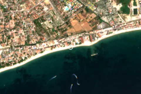
Within 1 km, the land is 58% built-up land, 18% grassland and 15% tree cover (satellite land-cover map, 2021): an urban beach. Water makes up 49% of that circle.
- Built 58%
- Grass 18%
- Tree 15%
- Crop 5%
- Bare 5%
Land cover: ESA WorldCover 2021 (10 m). Orientation from OpenStreetMap land polygons sampled in 36 directions; depths and heights from the GEBCO 2020 grid (about 450 m cells), indicative only.
Bathing water quality
The official EU bathing-water site “Playa De Cap De Sant Pere Pm1”, 470 m from the beach centre, was rated Good for the 2025 season. It was Excellent in 9 of its 11 classified seasons since 2015.
- 2015Excellent
- 2016Excellent
- 2017Excellent
- 2018Excellent
- 2019Excellent
- 2020Excellent
- 2021Excellent
- 2022Excellent
- 2023Excellent
- 2024Good
- 2025Good
Source: European Environment Agency, EU Bathing Water Directive assessments · national site profile. Classes are based on four seasons of bacteriological sampling.
OpenStreetMap shows no lifeguard station within 1 km. Seasonal lifeguard posts are often unmapped, so check on site.
Photos


From above
Facilities within 1 km
- 39Restaurants, cafés & bars
- 8Public toilets
- –Showers
- 1Drinking water
- 18Car parks
- –Lifeguard stations
- 13Hotels & guesthouses
- 4Campsites
- 4Grocery shops
- 1Water-sports spots
- 23Bus stops (1.5 km)
- 2Cash machines
- 3Bike rental
Food and drink mapped within 1 km: 25 restaurants, 2 cafés, 11 bars and 1 fast-food outlet. Accommodation: 13 hotels and guesthouses.
Counted within 1 km of the beach (bus stops 1.5 km) from OpenStreetMap features and Overture Maps places, release of 2026-10. Unmapped does not mean absent.
Around the beach
Diving & boat hire
- Amigo24 110 m W
Campsites
- Camping la Corona 570 m NW
- Camping Cambrils Caban 970 m NW
- Sangulí Camping & Resort 970 m N
Getting there
| Airport | Code | Distance | Direction |
|---|---|---|---|
| Reus Airport Reus | REU | 9.8 km | north-east |
| Josep Tarradellas Barcelona-El Prat Airport Barcelona | BCN | 84.9 km | east |
| Lleida-Alguaire Airport Lleida | ILD | 87.3 km | north-west |
Straight-line distances from the beach; road distance is usually 20–40% longer.
Local transport: 23 bus stops within 1.5 km and 18 mapped car parks within 1 km.
7 towns and villages of 1,000+ people lie within 10 km (about 212.4K residents); within 30 km there are 40 (about 448.7K).
Reference
Cap de Sant Pere has an article on the CA Wikipedia: Platja del Cap de Sant Pere.
Wikidata item Q20102362 · classified as golden sand beach and urban beach.
Map and nearby beaches
Loading map…
Open in OpenStreetMap · Directions in Google Maps
| Beach | Distance | Warmest sea | Length | Surface |
|---|---|---|---|---|
| Cap de Sant Pere | – | 25.9 °C | 590 m | Sand |
| Vilafortuny | 900 m W | 25.9 °C | 1.9 km | Sand |
| platja de Ponent | 1.2 km E | 25.8 °C | 1.1 km | Sand |
| L'Esquirol | 2.0 km W | 25.9 °C | 719 m | Sand |
| Llevant Beach | 2.5 km E | 25.8 °C | 1.2 km | – |
| El Cavet | 2.8 km W | 25.9 °C | 725 m | Sand |
| Caleta de les Ferreries | 3.1 km E | 25.8 °C | – | – |
- Vilafortuny900 m WCompare
- platja de Ponent1.2 km ECompare
- L'Esquirol2.0 km WCompare
- Llevant Beach2.5 km ECompare
- El Cavet2.8 km WCompare
- Caleta de les Ferreries3.1 km ECompare
- Prat d'En Fores i Regueral3.3 km WCompare
- Platja dels Capellans3.4 km ECompare
Data on this page
- Air temperature, rain, cloud, wind, humidity: NASA POWER climatology 2001–2020, 0.5° grid.
- Sea temperature: NOAA OISST v2.1 monthly normals 1991–2020, nearest ocean cell 21.9 km away.
- Beach outline, surface, rules and public facilities: OpenStreetMap contributors (ODbL), feature r1748107; restaurants, cafés, bars and lodging: Overture Maps places (CDLA-Permissive-2.0).
- Water body, status and length: Wikidata (CC0).
- Towns and time zone: GeoNames (CC BY 4.0). Airports: OurAirports (public domain). Sunrise and sunset: NOAA solar equations.
- Photos: Wikimedia Commons, author and licence under each image.
- Satellite view: Copernicus Sentinel-2 (ESA), scene S2B_31TCF_20250814_0_L2A.
- Orientation: OpenStreetMap land polygons (ODbL). Depth and terrain: GEBCO 2020 grid.
- Bathing-water quality: European Environment Agency (site ES514M038806).
- Settlements: GeoNames places with 1,000+ inhabitants.
- Land cover: ESA WorldCover 2021, 10 m (CC BY 4.0).
Data compiled 2026-10-13. Something wrong? Report a data error.