Indonesia / North Kalimantan
Pantai Ambalat
Pantai Ambalat is a beach, 14.7 km north-west of Sekatak Bengara (North Kalimantan, Indonesia). The sea averages 29.8 °C in May, its warmest month, and 28.6 °C in January; it stays at 21 °C or above all year.
Average sea surface temperature by month. Current month outlined.
Setting
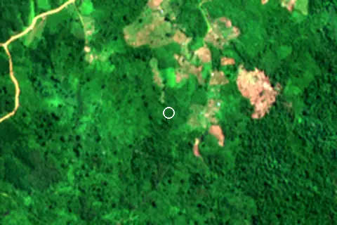
Within 1 km, the land is 100% tree cover (satellite land-cover map, 2021): a largely natural setting.
- Tree 100%
Land cover: ESA WorldCover 2021 (10 m).
Nearest services
The nearest place to eat or drink is 14.0 km north-west (Senja Coffe) and the nearest pharmacy or clinic is 15.4 km north-west (Apotek Sekatak Sehat).
| Service | Nearest mapped | Distance | Direction |
|---|---|---|---|
| Food and drink | Senja Coffe | 14.0 km | north-west |
| Pharmacy or clinic | Apotek Sekatak Sehat | 15.4 km | north-west |
Straight-line distance to the nearest feature within 20 km, from OpenStreetMap and Overture Maps places. A category is missing when nothing is mapped within 20 km.
Getting there
| Airport | Code | Distance | Direction |
|---|---|---|---|
| Juwata International Airport / Suharnoko Harbani AFB Tarakan | TRK | 51.3 km | east |
| Kalimarau Airport Tanjung Redeb - Borneo Island | BEJ | 120 km | south |
| Tawau Airport Tawau | TWU | 167 km | north-east |
Straight-line distances from the beach; road distance is usually 20–40% longer.
No town of 1,000+ people lies within 10 km; within 30 km there are 2 (about 0).
Map
Loading map…
Data on this page
- Sea temperature: NOAA OISST v2.1 monthly normals 1991–2020, nearest ocean cell 56.0 km away.
- Towns and time zone: GeoNames (CC BY 4.0). Airports: OurAirports (public domain). Sunrise and sunset: NOAA solar equations.
- Satellite view: Copernicus Sentinel-2 (ESA), scene S2B_50NNJ_20230729_0_L2A.
- Settlements: GeoNames places with 1,000+ inhabitants.
- Nearest services: OpenStreetMap and Overture Maps places within 20 km.
- Land cover: ESA WorldCover 2021, 10 m (CC BY 4.0).
- Search popularity: about 2.9K Google searches a month for the name (KeywordTool, October 2026).
Data compiled 2026-10-13. Something wrong? Report a data error.