Indonesia / Central Java
Pantai Cangkring
Pantai Cangkring is a beach, 1.5 km south-east of Jatiroto (Central Java, Indonesia). The sea averages 28.9 °C in March, its warmest month, and 25.0 °C in August; it stays at 21 °C or above all year.
Average sea surface temperature by month. Current month outlined.
Setting
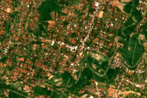
Within 1 km, the land is 79% tree cover, 14% cropland and 6% built-up land (satellite land-cover map, 2021): a largely natural setting.
- Tree 79%
- Crop 14%
- Built 6%
Land cover: ESA WorldCover 2021 (10 m).
Nearest services
The nearest place to eat or drink is 6.5 km north (Warung Makan Mbk Tutik), the nearest grocery shop is 5.2 km north (Stockist Nasa AD 1332), the nearest fuel station is 8.0 km north-east (SPBU Pertamina Jatisrono) and the nearest pharmacy or clinic is 7.1 km north (Depo Kutus Kutus Jatisrono Wonogiri).
| Service | Nearest mapped | Distance | Direction |
|---|---|---|---|
| Food and drink | Warung Makan Mbk Tutik | 6.5 km | north |
| Groceries | Stockist Nasa AD 1332 | 5.2 km | north |
| Accommodation | Pucang Hargorejo | 6.6 km | south-west |
| Pharmacy or clinic | Depo Kutus Kutus Jatisrono Wonogiri | 7.1 km | north |
| Fuel station | SPBU Pertamina Jatisrono | 8.0 km | north-east |
| Car park | — | 9.7 km | north-east |
Straight-line distance to the nearest feature within 20 km, from OpenStreetMap and Overture Maps places. A category is missing when nothing is mapped within 20 km.
Getting there
| Airport | Code | Distance | Direction |
|---|---|---|---|
| Adisoemarmo International Airport Surakarta | SOC | 58.3 km | north-west |
| Adisutjipto International Airport Yogyakarta | JOG | 77.3 km | west |
| Dhoho International Airport Kediri | DHX | 91.8 km | east |
Straight-line distances from the beach; road distance is usually 20–40% longer.
1 town or village of 1,000+ people lie within 10 km (about 50.1K residents); within 30 km there are 2 (about 50.1K).
Map and nearby beaches
Loading map…
Open in OpenStreetMap · Directions in Google Maps
| Beach | Distance | Warmest sea | Length | Surface |
|---|---|---|---|---|
| Pantai Cangkring | – | 28.9 °C | – | – |
| Pantai Watu Karung | 41.9 km SW | 28.9 °C | 521 m | – |
| Pantai Buyutan | 42.7 km SW | 28.9 °C | – | – |
| Pantai Pangasan | 42.9 km S | 28.9 °C | – | – |
| Pantai Nampu | 43.0 km SW | 28.9 °C | 248 m | – |
| Sembukan Beach | 46.5 km SW | 28.9 °C | – | – |
| Pantai Wediombo | 56.4 km SW | 28.9 °C | 1.0 km | Sand |
- Pantai Watu Karung41.9 km SWCompare
- Pantai Buyutan42.7 km SWCompare
- Pantai Pangasan42.9 km SCompare
- Pantai Nampu43.0 km SWCompare
- Sembukan Beach46.5 km SWCompare
- Pantai Wediombo56.4 km SWCompare
- Siung Beach58.4 km SWCompare
- Timang Beach60.0 km SWCompare
Data on this page
- Sea temperature: NOAA OISST v2.1 monthly normals 1991–2020, nearest ocean cell 53.6 km away.
- Towns and time zone: GeoNames (CC BY 4.0). Airports: OurAirports (public domain). Sunrise and sunset: NOAA solar equations.
- Satellite view: Copernicus Sentinel-2 (ESA), scene S2A_49MEM_20230905_0_L2A.
- Settlements: GeoNames places with 1,000+ inhabitants.
- Nearest services: OpenStreetMap and Overture Maps places within 20 km.
- Land cover: ESA WorldCover 2021, 10 m (CC BY 4.0).
- Search popularity: about 12.1K Google searches a month for the name (KeywordTool, October 2026).
Data compiled 2026-10-13. Something wrong? Report a data error.