Japan / Tokyo
Okina Hama
Okina Hama is a beach facing south-south-east, 275 km south of Ogasawara (Tokyo, Japan). The sea averages 29.0 °C in July, its warmest month, and 22.6 °C in February; it stays at 21 °C or above all year.
Average sea surface temperature by month. Current month outlined.
Month by month
November at Okina Hama
Beach-day index 8.4/10 · Japan median 4.3
| Measure | Jan | Feb | Mar | Apr | May | Jun | Jul | Aug | Sep | Oct | Nov | Dec |
|---|---|---|---|---|---|---|---|---|---|---|---|---|
| Sea °C | 23.2 °C | 22.6 °C | 22.9 °C | 24.0 °C | 25.5 °C | 27.7 °C | 29.0 °C | 28.8 °C | 28.7 °C | 28.1 °C | 26.9 °C | 25.0 °C |
| High °C | 22° | 21° | 22° | 23° | 26° | 28° | 29° | 29° | 29° | 28° | 26° | 24° |
| Low °C | 20° | 20° | 21° | 22° | 25° | 27° | 28° | 28° | 28° | 27° | 25° | 23° |
| Rain mm | 43 | 32 | 54 | 79 | 171 | 97 | 111 | 155 | 137 | 129 | 77 | 78 |
| Cloud % | 66 | 61 | 59 | 60 | 63 | 50 | 53 | 60 | 52 | 48 | 56 | 68 |
| Wind m/s | 6.7 | 6.3 | 6.3 | 5.8 | 5.2 | 4.5 | 4.9 | 6.1 | 6.0 | 6.0 | 6.3 | 6.7 |
| Daylight h | 10.8 | 11.3 | 12.0 | 12.7 | 13.3 | 13.7 | 13.5 | 13.0 | 12.3 | 11.6 | 11.0 | 10.6 |
| Record high/low | 25°/17° | 25°/16° | 26°/17° | 26°/18° | 29°/20° | 30°/23° | 30°/26° | 30°/26° | 30°/25° | 30°/24° | 29°/22° | 27°/18° |
| Beach index | 7.1 | 7.1 | 7.3 | 7.8 | 7.8 | 8.6 | 8.4 | 7.8 | 8.1 | 8.2 | 8.4 | 7.8 |
Long-term monthly averages: air from NASA POWER (2001–2020), sea from NOAA OISST (1991–2020); records are the extremes of 2001–2020. How the index works.
When to go
The beach-day index peaks in June–July and September–November; June scores 8.6/10 with highs of 28 °C, sea at 27.7 °C and 97 mm of rain.
In June that is 1.9 points above the median of the 127 beaches in Japan covered by this atlas.
At its warmest the water here is 4.6 °C warmer than the Japan median for July (24.4 °C).
Across the year the sea averages 26.0 °C, warmer than 79% of the coastal beaches in the atlas.
May is the wettest month (171 mm) and February the driest (32 mm); the yearly total is about 1,160 mm.
Daylight runs from 10.6 hours in December to 13.7 hours in June; in mid-June the sun rises at 04:44 and sets at 18:24 local time.
Orientation, sun and shore
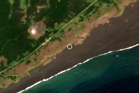
The shore faces south-south-east (160°). Open water fills about 36% of the horizon close by, which makes it an open stretch of shore.
At no time of year does the sun set over the sea here: sunset bearings run from 245° to 296°, behind the land.
Sunrise is over the sea in October–February.
Straight out to the south-south-east there is open water for more than 2,000 km, so the beach is exposed to long ocean swell. The beach is on an island of about 29 km².
About 1 km offshore the sea is roughly 240 m deep and 255 m at 3 km, so deep water starts close to shore. Behind the beach the ground is about 59 m above sea level 500 m inland and 81 m at 1.5 km, so the beach is backed by steep slopes or cliffs.
Orientation from OpenStreetMap land polygons sampled in 36 directions; depths and heights from the GEBCO 2020 grid (about 450 m cells), indicative only.
Nearest services
The nearest place to eat or drink is 4.4 km north (ネワパサNewa pasa) and the nearest pharmacy or clinic is 4.4 km north (一心駒込整骨院).
| Service | Nearest mapped | Distance | Direction |
|---|---|---|---|
| Food and drink | ネワパサNewa pasa | 4.4 km | north |
| Pharmacy or clinic | 一心駒込整骨院 | 4.4 km | north |
| Car park | — | 4.5 km | north-east |
Straight-line distance to the nearest feature within 20 km, from OpenStreetMap and Overture Maps places. A category is missing when nothing is mapped within 20 km.
Around the beach
Islands in view
- 硫黄島 2.2 km NE
Map and nearby beaches
Loading map…
Open in OpenStreetMap · Directions in Google Maps
| Beach | Distance | Warmest sea | Length | Surface |
|---|---|---|---|---|
| Okina Hama | – | 29.0 °C | – | – |
| Chidoriga Hama | 1.8 km NW | 29.0 °C | – | – |
| Hinode Hama | 4.7 km NE | 29.0 °C | – | – |
- Chidoriga Hama1.8 km NWCompare
- Hinode Hama4.7 km NECompare
Data on this page
- Air temperature, rain, cloud, wind, humidity: NASA POWER climatology 2001–2020, 0.5° grid.
- Sea temperature: NOAA OISST v2.1 monthly normals 1991–2020, nearest ocean cell 14.3 km away.
- Beach outline, surface, rules and public facilities: OpenStreetMap contributors (ODbL); restaurants, cafés, bars and lodging: Overture Maps places (CDLA-Permissive-2.0).
- Water body, status and length: Wikidata (CC0).
- Towns and time zone: GeoNames (CC BY 4.0). Airports: OurAirports (public domain). Sunrise and sunset: NOAA solar equations.
- Satellite view: Copernicus Sentinel-2 (ESA), scene S2C_54RWN_20250301_0_L2A.
- Orientation: OpenStreetMap land polygons (ODbL). Depth and terrain: GEBCO 2020 grid.
- Settlements: GeoNames places with 1,000+ inhabitants.
- Nearest services: OpenStreetMap and Overture Maps places within 20 km.
Data compiled 2026-10-13. Something wrong? Report a data error.