United States / Washington
Pioneer Square Habitat Beach
Pioneer Square Habitat Beach is a 99 m-long gravel inland beach on the Elliott Bay, 600 m south-west of Seattle (Washington, United States). Average daytime highs peak at 22 °C in August and drop to 3 °C in December.

Weather month by month
November at Pioneer Square Habitat Beach
Beach-day index 1.6/10 · United States median 3.3
| Measure | Jan | Feb | Mar | Apr | May | Jun | Jul | Aug | Sep | Oct | Nov | Dec |
|---|---|---|---|---|---|---|---|---|---|---|---|---|
| High °C | 4° | 5° | 7° | 11° | 16° | 18° | 22° | 22° | 18° | 12° | 7° | 3° |
| Low °C | -1° | -1° | 1° | 3° | 6° | 9° | 12° | 12° | 9° | 5° | 1° | -1° |
| Rain mm | 264 | 168 | 211 | 138 | 100 | 77 | 31 | 42 | 87 | 193 | 283 | 245 |
| Cloud % | 80 | 74 | 79 | 75 | 70 | 68 | 47 | 48 | 53 | 68 | 77 | 79 |
| Wind m/s | 2.2 | 2.0 | 1.9 | 1.6 | 1.4 | 1.3 | 1.2 | 1.2 | 1.3 | 1.7 | 2.1 | 2.2 |
| Daylight h | 8.8 | 10.2 | 11.8 | 13.6 | 15.1 | 16.0 | 15.6 | 14.3 | 12.7 | 11.0 | 9.4 | 8.5 |
| Record high/low | 14°/-17° | 16°/-15° | 19°/-10° | 27°/-7° | 32°/-1° | 34°/3° | 36°/6° | 35°/5° | 33°/1° | 25°/-7° | 18°/-17° | 13°/-18° |
| Beach index | 1.6 | 2.5 | 2.0 | 2.8 | 3.3 | 4.1 | 7.0 | 7.0 | 4.5 | 2.3 | 1.6 | 1.6 |
Long-term monthly averages: air from NASA POWER (2001–2020), sea from NOAA OISST (1991–2020); records are the extremes of 2001–2020. How the index works.
Setting
Within 1 km, the land is 88% built-up land, 6% tree cover and 6% bare ground, sand or rock (satellite land-cover map, 2021): an urban beach. Water makes up 30% of that circle.
- Built 88%
- Tree 6%
- Bare 6%
Land cover: ESA WorldCover 2021 (10 m).
This is not a sea beach, so no sea-temperature normals are shown.
When to go
The beach-day index peaks in July–August; July scores 7.0/10 with highs of 22 °C and 31 mm of rain.
In July that is 0.9 points below the median of the 2,466 beaches in United States covered by this atlas.
November is the wettest month (283 mm) and July the driest (31 mm); the yearly total is about 1,840 mm.
Daylight runs from 8.5 hours in December to 16.0 hours in June; in mid-July the sun rises at 05:26 and sets at 21:04 local time.
Facilities within 1 km
- 671Restaurants, cafés & bars
- 12Public toilets
- –Showers
- 7Drinking water
- 98Car parks
- –Lifeguard stations
- 63Hotels & guesthouses
- 84Grocery shops
- 1Marinas & slipways
- 158Bus stops (1.5 km)
- 20Pharmacies & clinics
- 19Cash machines
- 3Viewpoints
- 2Historic sites
Food and drink mapped within 1 km: 466 restaurants, 105 cafés, 84 bars and 16 fast-food outlets. Accommodation: 63 hotels and guesthouses.
Counted within 1 km of the beach (bus stops 1.5 km) from OpenStreetMap features and Overture Maps places, release of 2026-10. Unmapped does not mean absent.
Photos


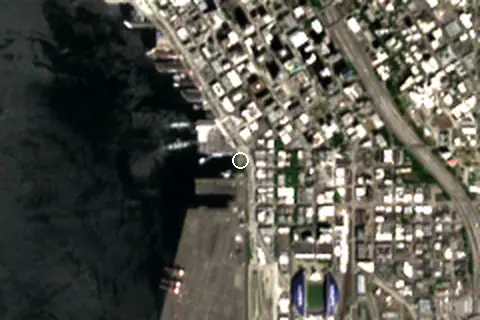
From above
Around the beach
Attractions & museums
- Golden Loom Rug Gallery museum 190 m SE
- Seattle Underground museum 220 m NE
- Seattle Death Museum museum 260 m NE
- Martyr Sauce Pop Art Museum museum 300 m SE
- Friend Museum museum 380 m SE
- Last Resort Fire Department Museum museum 380 m SE
Historic sites
- Washington Street Public Boat Landing monument 40 m SE
- Garden of Remembrance monument 760 m N
Nature
- Klondike Gold Rush National Historical Park nature reserve 420 m SE
- First Hill peak 1.4 km NE
Lighthouses & piers
- King County Ferry District Maintenance Facility pier 100 m SW
- Pier 48 pier 160 m SW
- Pier 53 pier 320 m NW
- Mooring dolphin pier 330 m W
- Seattle Fire Station #5 Pier pier 340 m NW
- Pier 54 pier 400 m NW
Marinas
- Pier 48 460 m S
Getting there
| Airport | Code | Distance | Direction |
|---|---|---|---|
| King County International Airport - Boeing Field Seattle | BFI | 8.7 km | south |
| Seattle–Tacoma International Airport Seattle | SEA | 17.2 km | south |
| Seattle Paine Field International Airport Everett | PAE | 34.2 km | north |
Straight-line distances from the beach; road distance is usually 20–40% longer.
Local transport: 158 bus stops within 1.5 km, rail station Pioneer Square (420 m), rail station Seattle King Street (640 m), ferry terminal West Seattle Water Taxi & Colman Dock (170 m), ferry terminal Vashon Island Water Taxi & Colman Dock (180 m) and 98 mapped car parks within 1 km.
7 towns and villages of 1,000+ people lie within 10 km (about 850.3K residents); within 30 km there are 82 (about 2.4M).
Reference
Pioneer Square Habitat Beach is a 200-foot (61 m)-long urban beach south of the Colman Dock in Seattle's Pioneer Square district, in the U.S. state of Washington. It began construction in 2018 and opened in 2023 as part of a multi-year redevelopment of the waterfront and the Alaskan Way Seawall.
Wikidata item Q120429811 · classified as urban beach.
When people look it up
The EN Wikipedia article was read 298 times in the 12 months to August 2026. Interest peaks in July (40 views), 2.9× the quietest month.
Map and nearby beaches
Loading map…
Open in OpenStreetMap · Directions in Google Maps
| Beach | Distance | Warmest sea | Length | Surface |
|---|---|---|---|---|
| Pioneer Square Habitat Beach | – | – | 99 m | Gravel |
| Mount Baker Beach | 4.1 km SE | – | 54 m | Fine gravel |
| Alki Beach Park | 5.7 km SW | – | 923 m | Sand |
| Brighton Beach | 8.7 km SE | – | – | – |
| Pritchett Island Beach | 9.7 km SE | – | 73 m | – |
| Golden Gardens Park | 11.0 km NW | 11.9 °C | – | – |
| Matthews Beach | 11.6 km NE | – | 117 m | – |
- Mount Baker Beach4.1 km SECompare
- Alki Beach Park5.7 km SWCompare
- Brighton Beach8.7 km SECompare
- Pritchett Island Beach9.7 km SECompare
- Golden Gardens Park11.0 km NWCompare
- Matthews Beach11.6 km NECompare
- Lake City Beach Park14.2 km NCompare
- Rosemont Beach18.4 km ECompare
Data on this page
- Air temperature, rain, cloud, wind, humidity: NASA POWER climatology 2001–2020, 0.5° grid.
- Beach outline, surface, rules and public facilities: OpenStreetMap contributors (ODbL), feature w1189020987; restaurants, cafés, bars and lodging: Overture Maps places (CDLA-Permissive-2.0).
- Water body, status and length: Wikidata (CC0).
- Towns and time zone: GeoNames (CC BY 4.0). Airports: OurAirports (public domain). Sunrise and sunset: NOAA solar equations.
- Photos: Wikimedia Commons, author and licence under each image.
- Satellite view: Copernicus Sentinel-2 (ESA), scene S2B_10TET_20250608_0_L2A.
- Settlements: GeoNames places with 1,000+ inhabitants.
- Land cover: ESA WorldCover 2021, 10 m (CC BY 4.0).
Data compiled 2026-10-13. Something wrong? Report a data error.