United States / Florida
West Palm Beach
West Palm Beach is a coastal resort area in Florida, United States. The sea averages 29.5 °C in August, its warmest month, and 25.0 °C in February; it stays at 21 °C or above all year.
Average sea surface temperature by month. Current month outlined.

OpenStreetMap shows no lifeguard station within 1 km. Seasonal lifeguard posts are often unmapped, so check on site.
Services in the resort
- 241Restaurants, cafés & bars
- 1Public toilets
- –Showers
- 4Drinking water
- 148Car parks
- –Lifeguard stations
- 18Hotels & guesthouses
- 20Grocery shops
- 5Water-sports spots
- 1Marinas & slipways
- 29Bus stops (1.5 km)
- 4Pharmacies & clinics
- 2Bike rental
Food and drink mapped within 1 km: 166 restaurants, 30 cafés, 42 bars and 3 fast-food outlets. Accommodation: 18 hotels and guesthouses.
Counted within 1 km of the beach (bus stops 1.5 km) from OpenStreetMap features and Overture Maps places, release of 2026-10. Unmapped does not mean absent.
Month by month
October at West Palm Beach
Beach-day index 8.5/10 · United States median 4.5
| Measure | Jan | Feb | Mar | Apr | May | Jun | Jul | Aug | Sep | Oct | Nov | Dec |
|---|---|---|---|---|---|---|---|---|---|---|---|---|
| Sea °C | 25.1 °C | 25.0 °C | 25.2 °C | 26.0 °C | 27.1 °C | 28.3 °C | 29.2 °C | 29.5 °C | 29.2 °C | 28.4 °C | 27.2 °C | 26.1 °C |
| High °C | 22° | 24° | 25° | 26° | 28° | 29° | 30° | 30° | 29° | 28° | 25° | 24° |
| Low °C | 18° | 19° | 20° | 22° | 24° | 26° | 26° | 27° | 26° | 24° | 22° | 20° |
| Rain mm | 56 | 53 | 70 | 71 | 129 | 206 | 174 | 197 | 191 | 112 | 65 | 65 |
| Cloud % | 45 | 44 | 42 | 42 | 47 | 64 | 60 | 58 | 59 | 48 | 41 | 45 |
| Wind m/s | 5.3 | 5.1 | 5.3 | 5.0 | 4.6 | 3.7 | 3.4 | 3.5 | 4.0 | 4.9 | 5.2 | 5.2 |
| Daylight h | 10.6 | 11.2 | 12.0 | 12.8 | 13.4 | 13.8 | 13.7 | 13.1 | 12.4 | 11.6 | 10.9 | 10.5 |
| Record high/low | 28°/7° | 28°/8° | 30°/10° | 32°/14° | 33°/18° | 33°/23° | 32°/24° | 33°/25° | 32°/23° | 31°/14° | 30°/12° | 29°/6° |
| Beach index | 7.7 | 8.3 | 8.6 | 8.8 | 8.4 | 7.7 | 8.0 | 7.8 | 7.9 | 8.5 | 8.9 | 8.3 |
Long-term monthly averages: air from NASA POWER (2001–2020), sea from NOAA OISST (1991–2020); records are the extremes of 2001–2020. How the index works.
When to go
The beach-day index peaks in February–May and October–December; November scores 8.9/10 with highs of 25 °C, sea at 27.2 °C and 65 mm of rain.
In November that is 5.6 points above the median of the 2,466 beaches in United States covered by this atlas.
At its warmest the water here is 7.0 °C warmer than the United States median for August (22.5 °C).
Across the year the sea averages 27.2 °C, warmer than 82% of the coastal beaches in the atlas.
June is the wettest month (206 mm) and February the driest (53 mm); the yearly total is about 1,390 mm.
Daylight runs from 10.5 hours in December to 13.8 hours in June; in mid-November the sun rises at 06:39 and sets at 17:30 local time.
Orientation, sun and shore
The shore faces east (90°). Open water fills about 6% of the horizon close by, which makes it a sheltered cove or bay.
At no time of year does the sun set over the sea here: sunset bearings run from 244° to 297°, behind the land.
The opposite shore is only about 500 m away to the east, which keeps the water sheltered from big waves.
The sea floor is still within the shallow coastal margin 1 km out; 3 km offshore the depth is about 14 m. Behind the beach the ground is about 13 m above sea level 500 m inland and 6 m at 1.5 km, a flat coastal plain.
Within 1 km, the land is 84% built-up land, 8% tree cover and 6% grassland (satellite land-cover map, 2021): an urban beach. Water makes up 24% of that circle.
- Built 84%
- Tree 8%
- Grass 6%
Land cover: ESA WorldCover 2021 (10 m). Orientation from OpenStreetMap land polygons sampled in 36 directions; depths and heights from the GEBCO 2020 grid (about 450 m cells), indicative only.
Getting there
| Airport | Code | Distance | Direction |
|---|---|---|---|
| President Donald J. Trump International Airport West Palm Beach | DJT | 5.5 km | south-west |
| Fort Lauderdale Hollywood International Airport Fort Lauderdale | FLL | 72.2 km | south |
| Miami-Opa Locka Executive Airport Miami | OPF | 92.6 km | south |
Straight-line distances from the beach; road distance is usually 20–40% longer.
Local transport: 29 bus stops within 1.5 km, rail station Brightline West Palm Beach (440 m), rail station West Palm Beach (960 m) and 148 mapped car parks within 1 km.
14 towns and villages of 1,000+ people lie within 10 km (about 219.9K residents); within 30 km there are 37 (about 760.6K).
Photos


From above
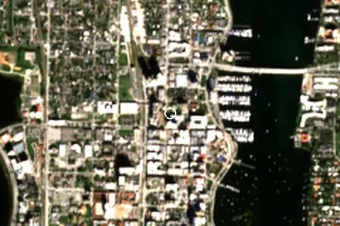
Around the beach
Attractions & museums
- Richard and Pat Johnson Palm Beach County History Museum museum 40 m NE
- Art Haus museum 470 m S
- Henry Morrison Flagler Museum museum 980 m E
Nature
- South Cove Natural Area nature reserve 970 m SE
Lighthouses & piers
- Palm Harbor Marina pier 460 m E
- West Palm Beach Public Dock pier 640 m SE
- Palm Beach Yacht Club & Marina pier 760 m NE
- South Cove Dock pier 960 m SE
Marinas
- Palm Harbor Marina 330 m E
Diving & boat hire
- Hmy Charter Vacations 340 m E
- Saveene Fractional Yachts 410 m SE
- Salty Dog Paddle West Palm Beach 450 m SE
- Palm Beach Ebike Rentals 540 m SW
- Mariner Iii 720 m NE
Map and nearby beaches
Loading map…
Open in OpenStreetMap · Directions in Google Maps
| Beach | Distance | Warmest sea | Length | Surface |
|---|---|---|---|---|
| West Palm Beach | – | 29.5 °C | – | – |
| Palm Beach | 2.0 km SE | 29.5 °C | – | – |
| Juno Beach | 17.9 km N | 29.5 °C | 4.0 km | – |
| Delray Beach | 28.3 km S | 29.6 °C | – | – |
| Deerfield Beach | 44.4 km S | 29.7 °C | – | – |
| Pompano Beach | 53.6 km S | 29.7 °C | – | – |
- Palm Beach2.0 km SECompare
- Juno Beach17.9 km NCompare
- Delray Beach28.3 km SCompare
- Deerfield Beach44.4 km SCompare
- Pompano Beach53.6 km SCompare
Data on this page
- Air temperature, rain, cloud, wind, humidity: NASA POWER climatology 2001–2020, 0.5° grid.
- Sea temperature: NOAA OISST v2.1 monthly normals 1991–2020, nearest ocean cell 20.4 km away.
- Beach outline, surface, rules and public facilities: OpenStreetMap contributors (ODbL); restaurants, cafés, bars and lodging: Overture Maps places (CDLA-Permissive-2.0).
- Towns and time zone: GeoNames (CC BY 4.0). Airports: OurAirports (public domain). Sunrise and sunset: NOAA solar equations.
- Photos: Wikimedia Commons, author and licence under each image.
- Satellite view: Copernicus Sentinel-2 (ESA), scene S2A_17RNK_20231231_0_L2A.
- Orientation: OpenStreetMap land polygons (ODbL). Depth and terrain: GEBCO 2020 grid.
- Settlements: GeoNames places with 1,000+ inhabitants.
- Land cover: ESA WorldCover 2021, 10 m (CC BY 4.0).
- Search popularity: about 301K Google searches a month for the name (KeywordTool, October 2026).
Data compiled 2026-10-13. Something wrong? Report a data error.