Vietnam / Ho Chi Minh City (HCMC)
Bãi biển 30 tháng 4
Bãi biển 30 tháng 4 is a beach, 14.4 km north-west of Cần Giờ (Ho Chi Minh City (HCMC), Vietnam). The sea averages 30.0 °C in May, its warmest month, and 26.1 °C in January; it stays at 21 °C or above all year.
Average sea surface temperature by month. Current month outlined.
Month by month
November at Bãi biển 30 tháng 4
Beach-day index 8.6/10 · Vietnam median 8.1
| Measure | Jan | Feb | Mar | Apr | May | Jun | Jul | Aug | Sep | Oct | Nov | Dec |
|---|---|---|---|---|---|---|---|---|---|---|---|---|
| Sea °C | 26.1 °C | 26.2 °C | 27.4 °C | 29.0 °C | 30.0 °C | 29.5 °C | 28.7 °C | 28.5 °C | 28.7 °C | 28.8 °C | 28.2 °C | 27.0 °C |
| High °C | 32° | 34° | 35° | 35° | 33° | 30° | 29° | 29° | 29° | 29° | 30° | 30° |
| Low °C | 20° | 20° | 22° | 24° | 25° | 24° | 24° | 23° | 23° | 23° | 22° | 21° |
| Rain mm | 11 | 4 | 9 | 35 | 156 | 184 | 202 | 193 | 188 | 198 | 89 | 30 |
| Cloud % | 56 | 39 | 42 | 54 | 74 | 81 | 83 | 84 | 84 | 77 | 72 | 72 |
| Wind m/s | 3.1 | 3.9 | 4.5 | 4.2 | 3.1 | 3.3 | 3.7 | 3.8 | 3.2 | 2.5 | 2.6 | 2.6 |
| Daylight h | 11.6 | 11.8 | 12.1 | 12.4 | 12.6 | 12.7 | 12.7 | 12.5 | 12.2 | 11.9 | 11.7 | 11.5 |
| Record high/low | 37°/16° | 39°/16° | 40°/18° | 41°/21° | 41°/23° | 38°/21° | 34°/22° | 32°/21° | 33°/22° | 33°/18° | 36°/15° | 37°/15° |
| Beach index | 9.0 | 8.2 | 7.5 | 7.2 | 7.4 | 7.7 | 7.6 | 7.6 | 7.7 | 7.6 | 8.6 | 9.0 |
Long-term monthly averages: air from NASA POWER (2001–2020), sea from NOAA OISST (1991–2020); records are the extremes of 2001–2020. How the index works.
When to go
The beach-day index peaks in November–January; January scores 9.0/10 with highs of 32 °C, sea at 26.1 °C and 11 mm of rain.
In January that is 0.6 points above the median of the 66 beaches in Vietnam covered by this atlas.
At its warmest the water here is 1.5 °C warmer than the Vietnam median for May (28.5 °C).
Across the year the sea averages 28.2 °C, warmer than 92% of the coastal beaches in the atlas.
July is the wettest month (202 mm) and February the driest (4 mm); the yearly total is about 1,300 mm.
Daylight runs from 11.5 hours in December to 12.7 hours in June; in mid-January the sun rises at 06:14 and sets at 17:48 local time.
Setting
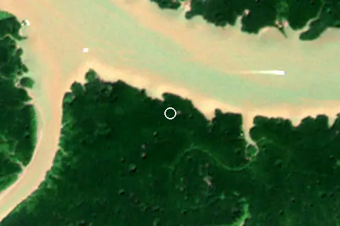
Within 1 km, the land is 100% mangroves (satellite land-cover map, 2021): a largely natural setting. Water makes up 40% of that circle.
- Mangrove 100%
Land cover: ESA WorldCover 2021 (10 m).
Average daytime highs reach 35 °C in March.
Facilities within 1 km
- 1Restaurants, cafés & bars
- –Public toilets
- –Showers
- –Car parks
- –Lifeguard stations
Food and drink mapped within 1 km: 1 restaurant.
Counted within 1 km of the beach (bus stops 1.5 km) from OpenStreetMap features and Overture Maps places, release of 2026-10. Unmapped does not mean absent.
Nearest services
The nearest place to eat or drink is 700 m south-west (ÔTÔ King), the nearest grocery shop is 9.3 km north (Chợ Tam Thôn Hiệp) and the nearest pharmacy or clinic is 9.8 km north-west (Bệnh Viện An Nghĩa).
| Service | Nearest mapped | Distance | Direction |
|---|---|---|---|
| Food and drink | ÔTÔ King | 700 m | south-west |
| Groceries | Chợ Tam Thôn Hiệp | 9.3 km | north |
| Accommodation | Ruby Homestay Cần Giờ | 2.6 km | south-west |
| Pharmacy or clinic | Bệnh Viện An Nghĩa | 9.8 km | north-west |
| Car park | — | 12.3 km | south |
| Public toilets | — | 11.3 km | south |
| Bus stop | Trạm tăng áp số 3 | 4.6 km | south |
Straight-line distance to the nearest feature within 20 km, from OpenStreetMap and Overture Maps places. A category is missing when nothing is mapped within 20 km.
Getting there
| Airport | Code | Distance | Direction |
|---|---|---|---|
| Tan Son Nhat International Airport Ho Chi Minh City | SGN | 41.8 km | north-west |
| Can Tho International Airport Can Tho | VCA | 137 km | west |
| Con Dao Airport Con Dao | VCS | 200 km | south |
Straight-line distances from the beach; road distance is usually 20–40% longer.
No town of 1,000+ people lies within 10 km; within 30 km there are 11 (about 1.1M).
Map and nearby beaches
Loading map…
Open in OpenStreetMap · Directions in Google Maps
| Beach | Distance | Warmest sea | Length | Surface |
|---|---|---|---|---|
| Bãi biển 30 tháng 4 | – | 30.0 °C | – | – |
| Bãi Dâu | 25.5 km SE | 29.9 °C | 301 m | – |
| Bãi biển Vũng Tàu | 28.5 km SE | 29.9 °C | 395 m | – |
| Bãi Sau (Vũng Tàu) | 31.1 km SE | 29.9 °C | 4.1 km | Sand |
| Bãi biển Long Cung | 31.5 km SE | 29.9 °C | – | – |
| Bãi biển Long Hải | 41.6 km E | 29.9 °C | 1.7 km | Sand |
| Bãi biển Phước Hải | 47.4 km E | 29.8 °C | 9.3 km | Sand |
- Bãi Dâu25.5 km SECompare
- Bãi biển Vũng Tàu28.5 km SECompare
- Bãi Sau (Vũng Tàu)31.1 km SECompare
- Bãi biển Long Cung31.5 km SECompare
- Bãi biển Long Hải41.6 km ECompare
- Bãi biển Phước Hải47.4 km ECompare
Data on this page
- Air temperature, rain, cloud, wind, humidity: NASA POWER climatology 2001–2020, 0.5° grid.
- Sea temperature: NOAA OISST v2.1 monthly normals 1991–2020, nearest ocean cell 15.8 km away.
- Beach outline, surface, rules and public facilities: OpenStreetMap contributors (ODbL); restaurants, cafés, bars and lodging: Overture Maps places (CDLA-Permissive-2.0).
- Towns and time zone: GeoNames (CC BY 4.0). Airports: OurAirports (public domain). Sunrise and sunset: NOAA solar equations.
- Satellite view: Copernicus Sentinel-2 (ESA), scene S2B_48PYS_20240127_0_L2A.
- Settlements: GeoNames places with 1,000+ inhabitants.
- Nearest services: OpenStreetMap and Overture Maps places within 20 km.
- Land cover: ESA WorldCover 2021, 10 m (CC BY 4.0).
- Search popularity: about 2.4K Google searches a month for the name (KeywordTool, October 2026).
Data compiled 2026-10-13. Something wrong? Report a data error.